
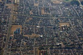
- Province: Western Cape
- Coordinates: 34°3′2″S “18°37′5″E
- Area: 43.76 km2
- Municipality: City of Cape Town
Mitchell’s Plain is a large residential area located on the Cape Flats within the City of Cape Town. It lies southeast of Cape Town and inland from the coast along False Bay. Mitchell’s Plain borders communities such as Khayelitsha and Strandfontein and forms one of the largest residential areas in the metropolitan region.
History of Mitchells Plain
Mitchells Plain is one of the largest residential areas on the Cape Flats. It was planned and developed by the apartheid government during the 1970s as a major new residential area for Coloured residents. The first houses were built in 1975, and the first residents moved into Westridge when Mitchells Plain was officially opened in April 1976.
The development was part of the wider housing policies of the apartheid era. Families who had been forcibly removed from areas of Cape Town that were declared for other racial groups, including District Six after it was declared a white area in 1966, were among those who moved to Mitchells Plain. The township was planned on a large scale, with wide arterial roads, open spaces, schools and other public facilities incorporated into the layout.
The scale of the development was unusual for Cape Town. Construction took place across a large area of the Cape Flats, which at the time was still relatively open and contained extensive sandy areas. Houses were built in different forms, including freestanding homes, semi-detached houses and maisonettes. Development continued throughout the late 1970s and early 1980s, with thousands of families moving into the new suburbs.
The origin of the name Mitchells Plain is uncertain. One explanation is that it was named after a farmer associated with the land, while another connects it with Major Charles Cornwallis Michell, the first Surveyor-General of the Cape Colony. Neither explanation can be stated with complete certainty.
Mitchells Plain was planned as a collection of neighbourhoods rather than a single uniform suburb. These include Beacon Valley, Eastridge, Lentegeur, Westridge, Strandfontein, Bayview, Colorado, Rondevlei, Wavecrest, Weltevreden Glen and Portland. The area also developed a substantial commercial centre, with the Town Centre opening in 1980 and later shopping centres adding to its role as a major regional hub.
Transport was an important part of the planning of Mitchells Plain. A railway line opened in 1980, connecting the new residential areas with Cape Town and other parts of the southern suburbs. Major roads and arterial routes were also incorporated into the original plan, allowing the rapidly growing community to remain connected to the wider city.
Mitchells Plain has an important place in South Africa’s political history. On 20 August 1983, the United Democratic Front was launched at the Rocklands Community Centre. Delegates from hundreds of organisations gathered for the launch, followed by a public meeting attended by many thousands of people. The UDF became an important national organisation in the resistance to apartheid. Rocklands Community Centre, together with the surrounding Memorial Square, library and community healthcare centre, was declared a Provincial Heritage Site in 2019.
The suburb also developed a strong cultural identity. During the 1980s, young people in Mitchells Plain became involved in music, street dance and other forms of youth culture, while local sports clubs, churches and community organisations provided important meeting places. The area has produced and supported many musicians, artists and sporting figures.
As Mitchells Plain grew, it also experienced many of the social and economic difficulties found in rapidly expanding urban areas. Some neighbourhoods experienced unemployment, overcrowding, gang activity, substance abuse and the growth of informal settlements, particularly from the late 1980s onwards. These problems became part of the area’s more recent history but did not define the community as a whole.
Today Mitchells Plain is a large and established part of the Cape Flats, with hundreds of thousands of residents, schools, businesses, shopping centres, sports clubs, community organisations and public facilities. What began as a large planned housing development in the 1970s has developed into a collection of distinct neighbourhoods with its own history and strong community identity.
Read more about the story of the Cape Flats
The postal codes for Mitchells Plain are 7785 (Streets) and 7789 (Boxes)
Transport
Mitchells Plain is served by Metrorail, MyCiTi Bus, Golden Arrow Bus Services, and minibus taxis. See linked pages for details. Other options for getting around the Western Cape.
Things to see and do in Mitchell’s Plain
- Rocklands Civic Centre earned national heritage status in 2020 from the South African Heritage Resource Authority. The hall is famous for hosting the founding of the United Democratic Front (UDF. 12 Lancaster Rd, Rocklands, Mitchells Plain
- RLabs House 38 Silverhurst Street, an innovative, upscale cultural facility
- Bond Street Park Outdoor Gym, Bond Street, London Village
- Bonfoi Park Outdoor Gym Bonfoi Way, Westridge
- Drakensberg Park Outdoor Gym, Kilimanjaro Street, Tafelsig
- Galaxy Gym Park Outdoor Gym Galaxy Street, Rocklands
- Westridge Gardens
- Mnandi Beach
- Mitchell’s Plain Festival 021 439 8000
- Wolfgat Nature Reserve
Resources
Practical information for the Western Cape, regulations, permits and helpful tips. See the Colourdots coastal and nature use guide
Transport, Getting around:
There are three Metrorail stations in the suburb: Kapteinsklip, Mitchells Plain, and Lentegeur. Golden Arrow Bus services the area, and so do minibus taxis. See linked pages for details. Other options for getting around the Western Cape.

Useful Numbers in Mitchell’s Plain
Residents and visitors can find important local contact numbers below, including police, medical services, utilities, and community facilities
-
Emergency Services
- Police: 021 370 1706
- Fire: 021 444 3085
- Ambulance:0860 103 089
-
Medical
- Closest hospital;
- Mitchell’s Plain Day Hospital-021 392 5162
- Lentegeur Clinic-021 444 1428
-
Municipal & Utilities
- Water: 0860 103 089
- Electricity:0860 103 089
-
Transport & Roads
- Traffic department:021 378 1140
-
Community & Safety
- SPCA: The People’s Dispensary for Sick Animals – P D S A-021 371 2440
- 24-hour Poisons Information Helpline of the Western Cape: 0861 555 777.
- NSRI 087 094 9774
-
Local Contacts and Community Resources
- Home Affairs: 021 370 3100 / 3102 / 3103 / 3109
- Beacon Valley Community Centre 021 444 5584
- Portlands Indoor Sports Centre: 021 391 0783
- Swartklip Indoor Sports Centre: 021 444 5584/021 444 5586
- Weltevreden recreation centre: 021 392 5132
- Tafelsig Community Centre: 021 444 5586
- Mandalay community hall:021 444 5584
- Post office;Lentegeur Post Office-021 371 1324
- Library:021 391 4787
-
Schools in Mitchells Plain
- Mitchell’s Plain No 1 Primary School-021 371 0800
- Mitchell’s Plain Primary School-021 371 0800
- Mitchell’s Plain School of Skill-021 392 1213
- Meadowridge Primary School-021 376 1145
- Harvester Primary School-021 371 9402
- Mitchells Plain High School-073 835 5348
- Springdale Primary School-021 371 6910
- Mondale High School-021 392 7031
- Northwood Primary School-021 371 7510
- Lentegeur Secondary School-021 371 4161
- Oval North High School-021 376 1067
- Darul Arqam Islamic High School-021 391 5730
- Westport Primary School-021 392 6604
- Parkhurst Primary-021 371 8910
- Cedar High School-021 392 5737
- Rocklands Primary School-021 392 2010
- Portland High School-021 374 4141
- Yellowwood Primary School-021 392 0882
- Caradale Primary School- 0213912079
- Find a comprehensive list of Cape Town Emergency numbers HERE
- The City of Cape Town Public Emergency Communication Centre is available 24/7 For all life or property-threatening emergencies. Call 021 480 7700 from any phone or 107 from a landline or report online at https://bit.ly/3o4Ji3K
Other Cape Flats towns and suburbs include: Athlone; Atlantis; Belhar; Blue Downs; Crawford; Eerste Rivier; Epping; Grassy park; Hanover Park; Khayalitsha; Kuils River; Langa; Lansdowne; Lotus river; Macassar; Mannenberg; Nyanga; Ottery;and Philippi
- Colourdots is an independent regional information resource for the Western Cape.
Learn more about the project HERE