- Province: Western Cape
- Coordinates: 33.994°S 18.531°E
- Area: 2.09 km2
- Municipality; City of Cape Town
Jump to: History of Hanover Park | Useful Numbers in Hanover Park
Hanover Park lies south of Goodwood and east of Athlone, within the Cape Flats region of Cape Town. It is part of the greater Cape Town metropolitan area and is well connected by main roads and public transport to nearby suburbs such as Manenberg, Heideveld, and Philippi.
History of Hanover Park
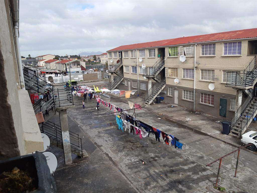
Hanover Park was established in 1969 on land that had previously been used as smallholdings. The area was developed during the apartheid era, and many residents were relocated there under the Group Areas Act. Families removed from areas such as District Six, Newlands, and Claremont were moved into council-owned rental accommodation consisting mainly of two- and three-storey apartment blocks.
The forced removals disrupted established communities and social networks, contributing to long-term social challenges that included poverty, overcrowding and gang-related violence. Over time, informal structures were built behind many of the original rental units, often relying on services connected to the existing buildings. In some areas, access to sanitation remains limited.
Long before Hanover Park existed, the Cape Flats formed part of the traditional territory of the San people, who lived and travelled throughout the region.
In the mid-1800s, the land formed part of Greyhill Farm, established by a German family who had received a grant in the area. German immigrants were among those encouraged to settle and farm parts of the Cape Flats during this period. A German Lutheran church dating from that era still stands on the boundary between Hanover Park and neighbouring Philippi, serving as a reminder of the area’s agricultural past. It was formally incorporated into the City of Cape Town municipality in1958.
Despite its challenges, Hanover Park is home to a resilient and active community. Local organisations, schools, churches and community groups play an important role in supporting residents and creating opportunities for young people. The area is known for its strong sense of community, as well as its music, cultural and sporting activities
The postal codes are 7780 (street) and 7782 (boxes)
Transport
Hanover Park is served by Golden Arrow Bus Services and minibus taxis. See linked pages for details. Other options for getting around the Western Cape.
weather in Hanover Park today
Browse businesses and places to visit in Hanover Park
Things to see and do in Hanover Park
- Surran Road Park Outdoor Gym Surran Road, Hanover Park
Resources
Practical information for the Western Cape: regulations, permits, and helpful tips. See the Colourdots coastal and nature use guide

Useful Numbers in Hanover Park
Residents and visitors can find important local contact numbers below, including police, medical services, utilities, and community facilities in and around
-
Emergency Services
- Police: 021 700 9045
- Fire: Ottery Fire Station-021 444 3500
- Ambulance:10177
-
Medical
- Closest hospital; Day Hospital-021 692 1240
- Community Health Centre-021 691 9744
- Pharmacy;Esack’s Pharmacy-021 691 8117
-
Municipal & Utilities
- Water:0860 103 089
- Electricity:0860 103 089
-
Transport & Roads
- Traffic Department: Hillstar Traffic Department-0860 103 089
-
Community & Safety
- NSRI 087 094 9774
- SPCA: -21 700 4140
-
Local Contacts and Community Resources
- Lansport community centre:021 444 0410
- Blomvlei community centre:021 444 0410
- Community centre:021 444 0410
- Civic Centre: 021 444 0410
- Library:-021 400 341
- Post office;Ottery Post Office-021 704 2209
-
Schools in Hanover Park
- Summit Primary School-021 691 7025
- Blomvlei Primary School-021 692 1377
- Belmor Primary School- 0216975832
- Crystal Secondary School-021 692 1378
- Parkfields Primary School-0216921428
- Find a comprehensive list of Cape Town Emergency numbers HERE
The City of Cape Town Public Emergency Communication Centre is available 24/7 For all life or property-threatening emergencies. Call 021 480 7700 from any phone or 107 from a landline or report online at https://bit.ly/3o4Ji3K
Other Cape Flats towns and suburbs include: Athlone; Atlantis; Belhar; Bishop Lavis;Blue Downs; Crawford; Crossroads; Eerste Rivier; Epping; Grassy park; Khayalitsha; Kuils River; Langa; Lansdowne; Lotus river; Macassar; Mannenberg; Mitchells Plain; Nyanga; Ottery;and Philippi
- Colourdots is an independent regional information resource for the Western Cape.
Learn more about the project HERE