Blue Downs is a large residential area in the eastern part of Cape Town with a mix of established suburbs, schools, shopping centres and community facilities. The area grew rapidly during the late apartheid and post-apartheid years and today forms an important part of the greater Cape Flats region.
Jump to: History of Blue Downs |Things to do in Blue Downs |Useful Numbers in Blue Downs
- Province: Western Cape
- Coordinates: 34°0′0″S 18°41
′51″E - Area: 24.57 km2
- Municipality; City of Cape Town
Blue Downs is located on the Cape Flats, east of central Cape Town, within the broader Oosterberg region. It lies near Kuils River, Eerste River, and Mfuleni, with Bellville to the north and Somerset West further southeast. The suburb has good road access via the R300 freeway, which links directly to the N1 and N2 highways, making it an important residential area for commuters travelling to Cape Town, Bellville, and surrounding industrial and commercial hubs.
History of Blue Downs
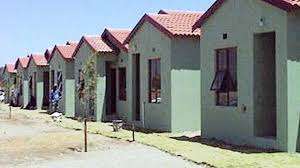
In the late 20th century. As Cape Town expanded, there was a push to develop more housing to accommodate the growing population. It began as a largely undeveloped area with scattered smallholdings and farms. The area was identified as a key area for residential development due to its proximity to major roads and transport networks.
In the 1980s and 1990s, there was significant growth as the government and private developers invested in building low- to middle-income housing. This development was part of a broader strategy to address housing shortages in Cape Town.
The postal codes in Blue Downs are 7100 (Streets) and 7105( Boxes)
Transport
Blue Downs is served by Golden Arrow Bus Services and minibus taxis. See linked pages for details. Other options for getting around the Western Cape.
Resources
Practical information for the Western Cape: regulations, permits, and helpful tips. See the Colourdots coastal and nature use guide
Things to do in Blue Downs
- Blue Downs Sports Stadium: can seat between 1000 and 2500 spectators
Hindle Rd Phone 021 444 7493
-
Blue Downs indoor swimming pool 021 444 1940
WEATHER IN BLUE DOWNS TODAY
Browse businesses and places to visit in Blue Downs

Useful Numbers in Blue Downs
Residents and visitors can find important local contact numbers below, including police, medical services, utilities, and community facilities
-
Emergency Services
- Police: Kleinvlei-021 902 8300
- Fire: Mfuleni Fire Station-021 909 9660
- Ambulance:10177
-
Medical
- Closest hospital/clinic – 021 444 8313
- Pharmacy;Medi rite-021 909 0054
-
Municipal & Utilities
- Water:0860 103 089
- Electricity: 0860 103 089
-
Transport & Roads
- Road Emergencies / SANRAL: 0800 204 204
-
Community & Safety
- SPCA: Cape Of Good Hope -021 700 4140
- NSRI 087 094 9774
- 24hour Poisons Information Helpline of the Western Cape: 0861 555 777.
-
Local Contacts and Community Resources
- Post office;021 909 0298
- Library: Melton Rose Public Library-021 444 0980
- Hillcrest community hall:021 444 7493
- Mfuleni Hall: 021 417 4912
- Mfuleni Training Centre: 021 444 7493
-
Schools in Blue Downs
- Blue Downs Primary School-021 909 6877
- Malibu High School-021 909 1105
- Happy Valley Primary School-021 908 0134
- Tuscany Glen High School-
- Bardale Primary School-021 901 0003
- Dennemere Primary School-021 905 2538
- Blackheath Primary School-021 905 4594
Other Cape Flats towns and suburbs include: Athlone; Atlantis; Belhar; Bonteheuwel; Crawford; Eerste Rivier; Epping; Grassy park; Hanover Park; Khayalitsha; Kuils River; Langa; Lansdowne; Lotus river; Macassar; Mannenberg; Mitchells Plain; Nyanga; Ottery;and Philippi
- Colourdots is an independent regional information resource for the Western Cape.
Learn more about the project HERE