- Province Western Cape
- Coordinates 33.7972°S 18.4620°E
- Area 1.39 km2
- Municipality City of Cape Town
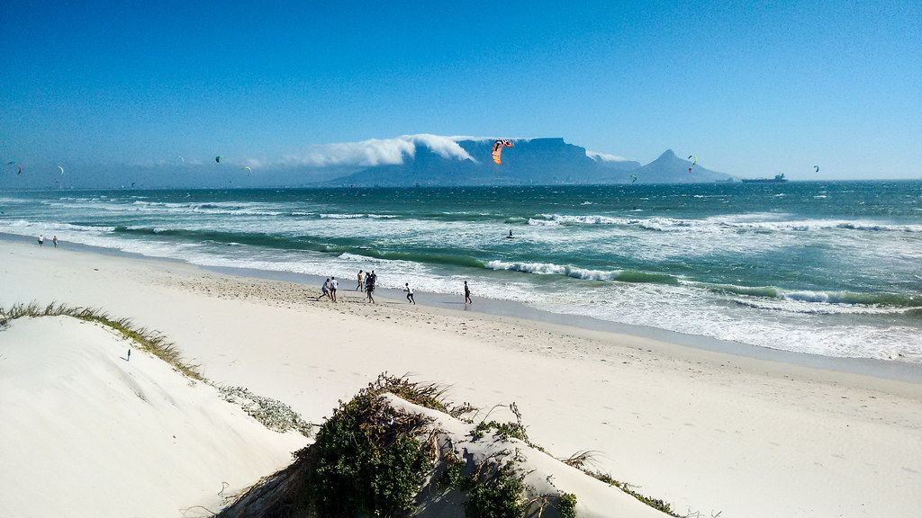
Bloubergstrand is a coastal suburb on the Atlantic shoreline north of Cape Town, along the West Coast. It lies between Milnerton to the south and Melkbosstrand to the north, with Table Bay stretching between the suburb and central Cape Town. The area sits just west of the R27 (West Coast Road), a major route linking Cape Town with the West Coast towns. Bloubergstrand faces directly toward Table Mountain across the bay, making it one of the most photographed viewpoints in the region.
Jump to: History of Bloubergstrand |Things to See and Do in Bloubergstrand |Useful Numbers in Bloubergstrand
History of Bloubergstrand
Also called Blaauwberg
Bloubergstrand is a seaside suburb. The name means “blue mountain beach” It is known particularly for the iconic view of Table Mountain over the ocean.
The first people the settlers documented living in Bloubergstrand were the Goringhaikonas. Their leader was “Harry die Strandloper,” also known as ‘Hadah’. Because he assisted the Dutch (VOC Dutch East India Company) working as an interpreter, in 1629, the captain of the ship London took “Harry die Strandloper” to England with him to deliver letters to the sailors. Thereby becoming the first postmaster in South Africa.
Battles
Many soldiers drowned when their ship ran into the rocks and overturned at the end of what is now Stadler Road. Frederick Louis Stadler was the owner of much of the land that is now Bloubergstrand.
Ghosts?
Reports of paranormal activity are common here. One of the most famous tales is of a phantom ship seen sailing off the coast, disappearing without a trace. Along the R27 West Coast Road, people have reported seeing shadowy figures darting through the dunes. Often referred to as “shadow people,” these figures are usually seen in passing, but some people have claimed to have directly encountered them.
The well-known restaurant “ Ons Huisie” was the first dwelling built on the property.
The postcodes for Blouberg are 7441 (streets) and 7436 (boxes)
Transport
Bloubergstrand is served by Golden Arrow Bus Services and minibus taxis. See linked pages for details. Other options for getting around the Western Cape.
Things to See and Do in Bloubergstrand
- Big Bay Beach has “Blue flag” status
- Ons Huisie restaurant 021 554 1553
Resources
Practical information for the Western Cape: regulations, permits, and helpful tips. See the Colourdots coastal and nature use guide
WEATHER IN BLOUBERG TODAY
Browse businesses and places to visit in Bloubergstrand

Useful Numbers in Bloubergstrand
Residents and visitors can find important local contact numbers below, including police, medical services, utilities, and community facilities
-
Emergency Services
- Police: Table View-021 521 3300
- Fire: 021 400 6949
- Ambulance: 10177
-
Medical
- Closest hospital;Netcare Blaauwberg Hospital-021 554 9000
- Pharmacy; Seaside Pharmacy-021 556 3950
-
Municipal & Utilities
- Water: 0860 103 089
- Electricity: 0860 103 089
-
Transport & Roads
- Traffic department: 021 550 1312
- Road Emergencies / SANRAL: 0800 204 204
-
Community & Safety
- SPCA: Cape Of Good Hope-021 700 4140
- NSRI 087 094 9774
- 24hour Poisons Information Helpline of the Western Cape: 0861 555 777.
-
Local Contacts and Community Resources
- Tourism: 021 521 1080
- community hall:021 814 1527
- Post office; Big Bay-021 554 0427
-
Schools in Blouberg
- Blouberg International School-021 557 9071
Blouberg Ridge Primary School-021 557 8422
Bloubergrant High School-021 557 6390
- Colourdots is an independent regional information resource for the Western Cape.
Learn more about the project HERE