Thomas Charles John Bain was responsible for many of the Western Cape’s historic mountain passes.
This page lists the main passes built or supervised by Bain in chronological order, with links to their locations and related towns.
The list includes mountain passes built, upgraded, or supervised by Thomas Charles John Bain, as well as selected early works completed with his father, Andrew Geddes Bain.
Andrew Geddes Bain became known for practical engineering solutions in an era before modern machinery and explosives were widely available. One of his most interesting techniques involved heating rock with large bonfires and then rapidly cooling it with cold water. The sudden temperature change caused the rock to crack and split naturally, allowing workers to remove large sections without extensive blasting. Bain used this method during pass construction, and it helped speed up work in difficult mountain terrain. Working largely with convict labour, basic tools, and careful surveying, he created roads that crossed mountain ranges previously considered almost impossible to traverse. His engineering work later inspired his interest in geology and led him to produce the first geological map of South Africa
“This page introduces historical mountain passes built by Thomas Bain in the Western Cape, and connects you to practical guides and local services for exploring them.”
Mountain Passes Built by Thomas Charles John Bain
Montagu Pass
1848 – The Montagu Pass was the first road linking George to Oudtshoorn. It was built by 250 convicts over three years for £36,000. It replaced the dangerous Cradock Pass. The Montagu pass covers 17.1 km, has 126 bends and gradients of up to 1:6. The gravel road ascends from Herold over the Outeniqua Mountains to George.
Many sections of the road are single, and it is sometimes necessary to reverse back to a wider point to allow oncoming traffic to pass. It was named after Colonial Secretary John Montagu, and is South Africa’s oldest unaltered pass. The pass is currently closed due to severe flood damage. Repair work is scheduled to be completed in August 2026
Michell’s Pass
1848 – Michell’s Pass, Ceres. Planned by Surveyor-General Charles Michell and built by Andrew Geddes Bain and his son Thomas. This pass winds through the Skurweberg and Witzenberg Mountains, linking Tulbagh, Wolseley, and Ceres. Michell, a military engineer, designed several key Cape passes and bridges, helping to establish a network of roads that supported regional growth. Michell’s Pass was widened and tarred in 1938 and remains an important historical route.
Bain’s Kloof Pass
1849 Bain’s Kloof Pass was done with father and son collaborating, using convict labour. It is 26,8 km in length from the bridge over the Breede River to the outskirts of Wellington. The Bain’s Kloof Pass (R301) provided a more direct route from this town to the more northern towns of Ceres and Worcester. It was favoured by oxwagons for its gentle gradients. The pass follows the Witte River in the northern section and includes historic features such as toll points, Dacre’s Pulpit, Bell Rocks, Bain’s Tunnel, and some bridges. The pass is now a national monument and was the main northern route until the Du Toits Kloof Pass opened in 1946
Meiringspoort
1854–1858 – Meiringspoort is one of South Africa’s most scenic and historic poorts. and it runs for16 km from De Rust into the Great Karoo. It was named after local farmer Petrus Johannes Meiring. Despite a history of floods and landslides, engineers created a remarkable route through dramatic scenery with gentle gradients and 63 bends. While the road is in great condition, drivers are advised to stay focused due to heavy trucks and limited shoulders. However, this is one of South Africa’s most scenic and historic poorts.
Schoemanspoort,
1855 – Schoemanspoort runs from Oudtshoorn to the Swartberg approach. It is part of the R328, Schoemanspoort links Oudtshoorn with the Cango Caves, and serves as a feeder route to Prince Albert via the Swartberg Pass. This 20 km poort rises 220 metres with an easy average gradient of 1:88, rarely steeper than 1:17. It is less famous than the nearby Meiringspoort and Seweweekspoort passes, but it winds along the Grobbelaarsrivier and offers stunning Cape Fold Mountain scenery on a gentle drive.
Grey’s Pass
1857–1858 – Grey’s Pass runs from Citrusdal to the Olifants River Valley. It was named after Sir George Grey. This 11 km pass employed 100–220 convict labourers. The old route, also known as Piekeniers Kloof, is no longer publicly accessible, as ownership and maintenance have reverted to private landowners. The northern section can be reached near the historic Modderfontein farm, while the southern part descends to the valley floor across private farmland. Today, Grey’s Pass is best attempted only by serious pass enthusiasts who can navigate the access permissions and historic remnants
Tulbagh Kloof,
1859–1860 – Tulbagh Kloof in the Tulbagh area is a 5 km pass that cuts through dramatic mountain scenery and connects the surrounding valleys. The route showcases the characteristic Cape folding mountains and offers a compact but historic example of early mountain pass construction
Seweweekspoort
1859–1862 – Seweweekspoort is also called the Little Karoo route and was likely named after Berlin Mission Society preacher Louis Zerwick. This 17 km pass runs from Laingsburg through the Swartberg Mountains. It is known for its spectacular geology, easy gradients, multiple river crossings, and its unique micro-climate. It offers camping, self-catering accommodation, and a scenic drive under the care of Cape Nature Conservation and the Swartberg and Towerkop Nature Reserves. Seweweekspoort is also a UNESCO World Heritage Site.
Prince Alfred’s Pass
1863–1867 – Prince Alfred’s Pass is a gravel road that runs from Knysna to Uniondale. It was built and named after Prince Alfred, Queen Victoria’s consort. This 70 km route that follows the R339 is widely regarded as Bain’s greatest engineering achievement. It is one of the longest mountain passes in South Africa. The construction of this road confronted the builders with almost every technical obstacle possible, from rugged terrain to difficult river crossings, making it a landmark in the history of Cape road construction.
Robinson Pass
1867–1869 – Robinson Pass runs between Oudtshoorn and Mossel Bay. It was named after Chief Inspector of Public Works Murrell Robinson. This pass on the R328 is a Southern Cape classic, it features sweeping curves, stunning views and a rich history, having been rebuilt several times over the past 140 years. The pass is often covered with mountain mist and regular rain, making it dangerous in places. A memorial stone halfway up the pass commemorates a bus of international tourists that overturned here, reminding visitors of the pass’s challenging conditions
The Seven Passes Road
1867–1883 – The Seven Passes Road is a scenic half-day drive that runs from George to Knysna. It was named for the number of mountain passes along its 75 km route, ending at Homtini Pass. The passes traverse towering mountains, indigenous forests, rolling hills and rivers. The route combines tarmac sections with mostly dirt roads, but is suitable for most vehicles. Heavy rains can sometimes affect parts of the road, so check conditions beforehand. Along the way are rivers and streams for cooling off, picnic spots, and stunning Garden Route scenery.
Tradouw Pass
1873 – Tradouw Pass runs between Barrydale and Swellendam. It is also known as Boschkloof or Southey Pass. Tradouw Pass, meaning “Women’s Path” in the old Khoi language, winds 16 km through the Langeberg Mountains, rising 219 metres in altitude. The pass is renowned for its dramatic and rugged scenery and is widely considered one of the top 20 tarred passes in the Western Cape.
Kogmanskloof pass
1873 – Kogmanskloof pass runs from Ashton to Montagu. It is also called Cogmans or Kockemans Kloof after a Khoikhoi clan. This 6.5 km route winds through towering rock formations and colourful farmland. Technically, it is more a poort than a pass. The road follows the river with minor elevation changes. Kogmanskloof lies at the heart of the Western Cape’s dried fruit and stone fruit growing region
Garcia’s Pass
1873 to 1877 – Garcia’s Pass, Riversdale to the Langeberg interior. It was named after Maurice Garcia; this 11.7 km pass links the coastal town of Riversdale with the inland Karoo town of Ladismith. Garcia’s Pass, together with Tradouw Pass to the west, played a key role in extending trade into the interior during the pioneering days of the 1820 Settlers.
The road winds gently through hills along the river, rising 397 metres in altitude with mostly easy gradients, although the southern side near Riversdale reaches a gradient of 1:10. The road is well maintained to a high standard, and it is suitable for all vehicles. This pass is a scenic yet lesser-known Southern Cape route.
Pakhuis Pass
1875–1877 – The Pakhuis Pass runs from Clanwilliam to Calvinia in the Cederberg. It was named after the nearby Pakhuisberg (“Packing Shed”) in the Krakadouw Mountains. This 26.4 km pass offers views of interesting rock formations. There are picnic spots, and the pass has access to some of the Cederberg’s best hiking trails. Most of the modern road follows Bain’s original alignment, and it remains suitable for all vehicles, though the northern switchbacks feature steep gradients and sharp corners.
Burgers Pass (Koo Pass)
1875–1877 – Burgers Pass (Koo Pass) is in the Montagu area. Originally called Koo Pass after the fruit-growing Koo Valley, the pass was later renamed for local councillor Mr Burger, who championed its upgrade. It was surveyed by Thomas Bain and begun by the Divisional Council in 1876. Construction was completed in 1887 at £1,000. The pass features long straights and sharp corners, requiring vigilance, and remains a key route through the Montagu area.
Rooihoogte Pass
1875–1877 – Rooihoogte Pass is also in the Montagu area and was originally known as Thomson’s Pass. This 7.6 km tarred route rises 370 metres with an average gradient of 1:20. It lies along the same road as Burgers (Koo) Pass and is reputedly the highest summit pass in the Western Cape. The pass offers spectacular views of the rugged Langeberg Mountains and is most enjoyable when driving downhill.
Verlatenkloof Pass,
1877–1878 – Verlatenkloof Pass from Sutherland in the Northern Cape to Matjiesfontein. The Verlatenkloof Pass means “Desolate Pass”. It is a major altitude-gaining tarred pass on the R354/R356. The route descends the Roggeveld Mountains through the Verlatenkloof, dropping 668 metres over 14.4 km with an average gradient of 1:22.
There are even steeper sections reaching 1:8. It is sometimes referred to by its older Dutch name, Verlatenkloof, or the Afrikaans form, Verlatekloof. Both names describe the same historic pass, which ranks among the longest and steepest mountain passes in South Africa
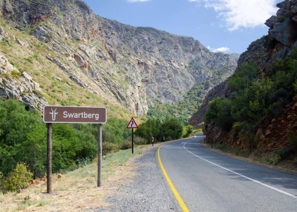
Swartberg Pass
1880–1888 – Swartberg Pass, Oudtshoorn to Prince Albert. Built by Thomas Bain, with 6 km constructed from the Prince Albert side by John Tassie, the Swartberg Pass links the Little Karoo to Prince Albert across the Swartberg range. At just under 24 km long, it was Bain’s final and most accomplished mountain pass and has been declared a national monument.
Widely regarded as South Africa’s most iconic gravel pass, it is known for its dramatic height, sweeping views and historic landmarks, many of which are signposted along the way. In good weather, the drive is about an hour of constantly changing scenery. The pass can challenge those with a fear of heights!
Baviaanskloof,
1880–1890 – Baviaanskloof is in the Eastern Cape and runs from Willowmore to Patensie. This 3 km pass traverses rugged valleys, tight poorts and mixed surfaces of bedrock, gravel and occasional concrete drifts. Drivers should expect low-water crossings, narrow verges, steep gradients and livestock, making daylight travel and cautious driving essential.
High-clearance vehicles are recommended for rough sections, and respect for conservation, private property, and safe gate use is required. Baviaanskloof rewards steady hands and patient driving with its unhurried, characterful scenery.
Bloukrans Pass
1884 – Bloukrans Pass, near Nature’s Valley, was planned and executed by master pass-builder Thomas Bain. The Bloukrans Pass was conceived when the government began exploring a coastal road between Port Elizabeth and Plettenberg Bay. Construction was made possible by the Great Fire of 1869. Due to the resultant clearing, it was possible for the first time to run a road through the formerly impenetrable Forest.
Its name translates from Afrikaans as “Blue Crag’s Pass”, reflecting the dramatic gorge it crosses alongside the Groot Rivier. It has long been regarded as one of South Africa’s most challenging and respected mountain passes. However, the road has since fallen into serious disrepair and is now closed to traffic, despite its historic and engineering significance.
Storms River Pass
1890s – Storms River Pass on the Garden Route was built in the late 19th century; the Storms River Pass was the first of the classic Tsitsikamma and Garden Route passes. The route displays Bain’s signature engineering style, with sweeping curves, high retaining walls and a manageable gradient of 1:15 designed for wagon traffic. Today, the pass lies within a national park and is closed to vehicles, but remains accessible to walkers and cyclists.
Precursors added for clarity
The Grootrivier Pass
1822–1823. The Grootrivier Pass at Nature’s Valley played an important role in the economic development of the Cape Colony. The pass was built along what is now the R102. Grootrivier Pass and its sister route, the Bloukrans Pass, presented significant engineering challenges, including unstable slopes, shale rock, heavy rainfall, and frequent rockfalls. Today, the Groot Rivier Pass is a scenic drive with tight corners, dramatic landscapes and travels through ancient Tsitsikamma forests.
Attakwaskloof Pass
Historic – The Attakwaskloof Pass runs from George to the interior. This 22.3 km gravel pass winds through the Outeniqua Mountains north of Mossel Bay and was part of the old Ox-Wagon Route from Heidelberg to de Vlugd. Most traffic these days uses the Robinson Pass, and the road is now primarily used by 4×4 enthusiasts and local farmers. Access to the road requires a permit from Bonniedale Farm 044 631 0900.
Locked gates mean the route is driven west to east, and keys can be obtained on issue of a permit at the start point. Some sections have been closed by Cape Nature, but the trail and alternate public routes allow partial exploration of this historic pass.
-
You may be interested in the Geology of the Western Cape
-
Dams of the Western Cape
-
Mining in the Western Cape
Explore nearby towns
The historic passes built by Thomas Bain are best experienced from nearby towns. For guides, accommodation, cafés, crafts and independent businesses in these areas, browse listings at:
- Local businesses and attractions in Riversdale
- Local businesses and attractions in Mossel Bay
- Local businesses and attractions in Barrydale
- Local businesses and attractions in George
- Oudtshoorn Local businesses and attractions in Oudtshoorn
- Local businesses and attractions in Montagu
- Colourdots is an independent regional information resource for the Western Cape.
Learn more about the project HERE