- Province: Western Cape
- District: Garden Route
- Coordinates:34°05′S 20°57′E
- Area:23.69 km2
- Municipality: Hessequa
Jump to:History of Heidelberg |Things to See and Do in Heidelberg |Useful Numbers in Heidelberg
Heidelberg lies about 275 km east of Cape Town on the N2 highway between Riversdale and Swellendam. The town sits at the foot of the Langeberg mountains and forms part of the Overberg region. Farming dominates the surrounding landscape, with wheat, sheep and dairy farms across the fertile plains, while the Breede River system lies to the north.
History of Heidelberg
Louis Fourie was granted grazing rights in this area by Simon Van Der Stel, where he settled on the banks of the Duivenhoks River. Here, he established the farm Doornboom. The Duivenhoks (Dovecote) river was named by an explorer, Isaq Schrijver, who observed a lot of doves where the river flows into the Indian Ocean, at Puntjie. The Duiwenhoks estuary is one of the last remaining unspoiled estuaries in the country, and a conservancy preserves its unique character.
The settlement was originally part of the Riversdale district until the Dutch Reformed Church bought a section of the farm on which to lay out a town that grew around the church. The new town was named Heidelberg after the town in Germany because of the Heidelberg Catechism that was practised in the church.
In 1903, the railway network reached Heidelberg, which was an important transport link for the fruit, wheat, and wool industries.
The license plate prefix for Heidelberg is CEG, and the postal code is 6665
local WEATHER TODAY
Browse businesses and places to visit inHeidelberg
Things to See and Do in Heidelberg
- The Giant Pumpkin Festival is held at the showgrounds in March
- Silver Mountain Music is an annual celebration of music and nature hosted in the Grootvadersbosch Valley. 079 335 0269
- Proe-bietjie Kunstefees Community festival 072 014 4501
- Goliath Davids Theatre Festival 023 342 8458
- Annual Agricultural Show (Landbouskou) February
- Annual Vlakte Marathon, annual road running event langebergathletics@gmail.com
- Annual Hessequa Harmonie Music and Arts Festival – performances by top local artists
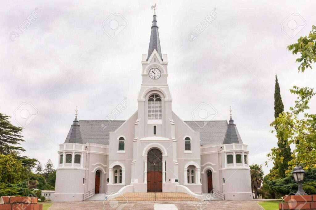
- Hotel Heidelberg (originally built around the 1840s), St Barnabas Anglican Church (1889) and the Dutch Reformed Church (1890); these two churches are built diagonally across the street from one another. Town Hall (1913) Stone Post Office (1936)
- Daneelshoogte
- Doringkraal pass
- Gysmanshoek pass
- Mountain Biking – there is a cycle trail of 6km on the reserve to enjoy with your own mountain bike and hiking trails, and day walks varying from 2 to 15km.
- GrootvadersboschNature Reserve
- The historical walking route
- Hessequa art route
- Wadrift pass
Resources
Practical information for the Western Cape, Regulations, permits and helpful tips. See the Colourdots coastal and nature use guide

Useful Numbers in Heidelberg
Residents and visitors can find important local contact numbers below, including police, medical services, utilities, and community facilities
-
Emergency Services
- Police: 028-7221910, 028-7228227
- Fire:044 805 5071
- Ambulance: 10177
-
Medical
- Closest hospital;Heidelberg Day Hospital-028 722 1441
- Clinic 028 722 1441
- Pharmacy;028 7221243
-
Municipal & Utilities
- Municipality-028 713 8000
- Water:028 713 8000
- Electricity :028 713 8000
-
Transport & Roads
- Road Emergencies / SANRAL: 0800 204 204
- Childline-116
-
Community & Safety
- 24 hour Poisons Information Helpline of the Western Cape: 0861 555 777.
- NSRI 087 094 9774
- SPCA: Swellendam-028 514 2083
-
Local Contacts and Community Resources
- Post office;028-7221910, 028-7228227
- Library:028 7221243
- Tourism 028 722 1068 Facebook page
-
Schools in Heidelberg
- Heidelberg High School -028 722 1384
- De Waalville Primary School – 0287221732
- Kairos Secondary School-028 722 2920
- Krombeksrivier NGK Primary School – 028 722 1180
Towns in the Hessequa district include: Albertinia; Gouritsmond; Groot Jongensfontein; Port Beaufort; Riversdale; Riviersonderend; Slang River; Stilbaai; Vermaaklikheid and Witsand
- Colourdots is an independent regional information resource for the Western Cape.
Learn more about the project HERE