- Province: Western Cape
- District: West Coast
- Coordinates:33°30′05″S 18°19′09″E
- Area:0.80 km2
- Municipality: Swartland
Jump to:History of Grotto Bay |Things to See and Do in Grotto Bay |Useful Numbers in Grotto Bay
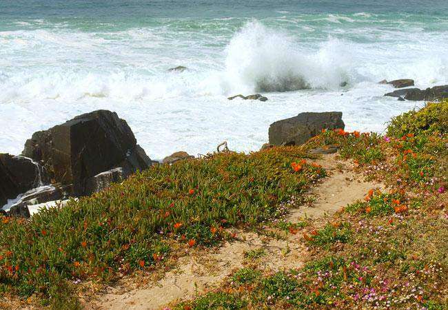
Grotto Bay is a small, private coastal settlement on the West Coast of the Western Cape, about 65 km north of Cape Town. It lies just off the R27 (West Coast Road) between Melkbosstrand and Yzerfontein. The village is situated within the West Coast National Park and forms part of a protected nature area. Access is controlled, and the area is known for its natural fynbos vegetation, wildlife, and elevated coastal views.
Grotto Bay overlooks the Atlantic Ocean, with rocky shores and sandy stretches below cliffs. The settlement is primarily residential, with holiday homes and no commercial centre within the village itself. Basic services and shops are available in nearby Melkbosstrand and Darling. The area is characterised by conservation-focused living, limited development, and strong environmental controls. Wildlife such as antelope species and small mammals are often seen within the estate.
Grotto Bay is just 45 minutes from Cape Town on the Route 27 West Coast Road. This is the area between Koeberg Private Nature Reserve and Yzerfontein. Incorporating 378 000 hectares, it stretches from the mouth of the Diep River at Milnerton and covers the entire coastal lowlands to far north of the Berg River at Velddrift. The Coastal Reserve is part of the far larger Cape West Coast Biosphere Reserve, which was proclaimed by UNESCO in 2000. This aims to ensure that any development remains ecologically sustainable. Also, the landscape is conserved for future generations.
History of Grotto Bay
The area is covered with Fynbos and masses of wildflowers in spring. Stretches of strandveld are home to a vast array of birds and other animals, including tortoises, steenbok, and duiker, and there is also an African Black Oystercatcher Conservation and Breeding programme in place.
Grotto Bay’s history is marked by its early use as a fishing and farming area. The name “Grotto Bay” reflects the natural grottoes or caves found along the coastline. The region has long attracted people for its natural resources and scenic beauty,
More about Grotto Bay Coastal Nature Reserve
local WEATHER TODAY
Browse businesses and places to visit in Grotto Bay
Things to See and Do in Grotto Bay
- Ostrich Trail is 10 km: From the waterhole through Long Pan to the Long Beach/River fire track crossing, north to the river mouth, then south along Long Beach and the Oystercatcher Trail to Kabeljoubank.
- Bokkie Trail 6 km: From the gate via the waterhole to Pan 2, through Long Pan to the Skuinsrots track crossing, then south along the fire track to the signal towers.
- Black Oystercatcher Coastal Hiking Trails. The African Black Oystercatcher conservation and breeding programme is run in partnership with the University of Cape Town and supported by estate property owners. The species is listed as Vulnerable in the International Red Data Book.
- A coastal trail runs north from Kabeljoubank along the shoreline to the river mouth. Beach access north of the river mouth is discouraged to protect breeding areas.
- Walkers will encounter pebble beaches, sandy bays, foam bays, cliffs, and long stretches of white sand. Licensed anglers may catch seasonal species such as stumpnose, kute, and kabeljou.
- You may encounter local wildlife here see our Western Cape Wildlife Guide for species commonly found in gardens, mountains and along the coast.
Resources
Practical information for the Western Cape: regulations, permits, and helpful tips. See the Colourdots coastal and nature use guide

Useful Numbers in Grotto Bay
Residents and visitors can find important local contact numbers below, including police, medical services, utilities, and community facilities. Grotto Bay is very small. Refer to the numbers in Darling.
-
Emergency Services
- Police: Darling 022 492 2314
- Ambulance: 10177
-
Medical
- Closest hospital; Wesfleur Hospital-021 571 8040
-
Community & Safety
- NSRI 087 094 9774
- 24-hour Poisons Information Helpline of the Western Cape: 0861 555 777.
- Childline South Africa: 116
-
Local Contacts and Community Resources
- Closest Post Office: Mamre -021 576 1001
- Closest library is Mamre Public Library-021 576 1661.
Towns in the Swartland district include: Chatsworth; Darling; Jakkalsfontein; Kalbaskraal; Koringberg; Malmesbury; Moorreesburg; Riebeek Kasteel and Yzerfontein;
- Colourdots is an independent regional information resource for the Western Cape.
Learn more about the project HERE