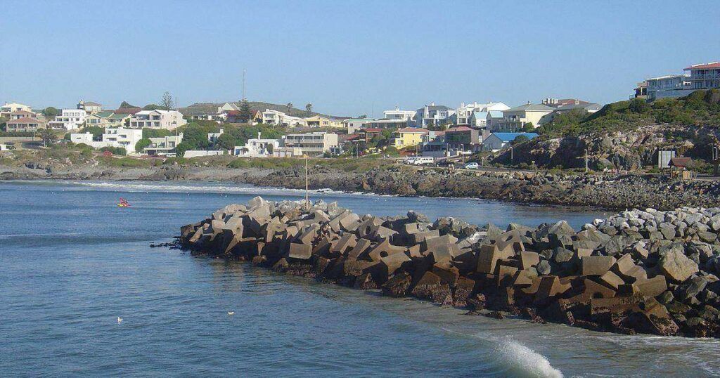
Yzerfontein

Yzerfontein is a coastal town on the Cape West Coast, north of Cape Town and south of Darling. Known for its long sandy beaches and fishing harbour, the town is a popular holiday and weekend destination within easy reach of the city.

Yzerfontein is situated on the West Coast of the Western Cape, approximately 90 km north of Cape Town. The town lies south of Darling and north of Grotto Bay, overlooking the Atlantic Ocean and the southern boundary of the West Coast National Park. It is accessed via the R27 West Coast Road and the R315. The name, translated from Dutch, is “Iron Fountain” due to the highly magnetic, iron-rich mineral spring that early farmers discovered right near the coastline.

History of Yzerfontein

Archaeological Finds

Archaeological digs in the area have uncovered remnants of food and tools left by ancient inhabitants. Dutch settlement in Yzerfontein began in 1732 when Cornelius Heufke was granted permission to graze his livestock on a farm called Eijzerfontein, named for the iron deposits in the local water.

The town grew in the 1930s when the farm  was bought by the Katz family, and they started dividing the farm into plots

Holiday Destination

The area became a popular seaside retreat for inland farmers. Many brought their supplies, including cows for milk and hens for eggs. To protect their livestock from jackals, farmers would keep their animals on an island that was cut off from the mainland at high tide.

blank
This old water trough was installed where 3rd Avenue is today. It was fed by a nearby underground spring, and filled daily so the animals could drink..

Cement Production

Yzerfontein was once known for producing lime and cement from the millions of mussel shells washed up on its beaches. The shells were collected and burned in stone kilns, two of which are still visible today. The resulting lime was used to make cement and whitewash for buildings, as well as a waterproofing mixture made with animal fat. Lime produced from Yzerfontein’s mussel shells was transported to Cape Town and used in construction, including the Castle of Good Hope. The kilns were declared national monuments in 1980.

.

blank

Salt Pans and Harbour

Yzerfontein also has a long history of salt production. The salt pan northeast of the town covers about 116 hectares and was originally used to extract salt. The salt was of good quality and was an important commodity in the days when salt was sometimes referred to as “white gold”, as it was essential for preserving meat and other food on long sea voyages. The pans were reportedly closely guarded to prevent sailors from taking salt illegally onto passing ships.

The remains of a harbour built in 1911 can still be seen. The harbour was used in connection with the area’s salt industry and for transporting salt to Cape Town.

The oldest surviving building in the area is Vishuis, a thatched cottage that now serves as the tourism office.

Today, the salt pan is mined for gypsum, a sulphate mineral used in products including fertiliser, plaster and wallboard.

World War II

During World War II, a few ships were torpedoed near Cape Town, so 17 radar stations were built in 1943. The local station was operated by six women who tracked enemy ships and air activity, watching the screens in five-hour shifts. They had to take an oath of secrecy. The buildings were fenced off and guarded by Zulu watchmen armed with assegais. Read about Operation Eisbär and the  U-boat attacks around the Western Cape coast


blank

Town Development

In 1937, parts of the farm were sold to “Yzerfontein Seaside Estates,” and the area received town status, being referred to as a “township.” It became a Local Area in 1960, and a Local Council was elected in 1989. The motto on the town coat of arms is Mare didat, flores decorat, meaning ‘the sea enriches,

Meeurots (Gull Rock)

About nine kilometres offshore from Yzerfontein lies Meeurots, or Gull Rock, a jagged island that supports a large colony of seabirds. In the late 19th century, Yzerfontein was known for guano collection. Labourers would row out to the steep, slippery cliffs, where they scraped bird droppings from the rock and loaded them onto boats. The guano was exported to Europe, where it was valued as a high-quality fertiliser.

Sixteen Mile Beach

Yzerfontein’s Sixteen Mile Beach is described as the longest uninterrupted sandy beach on the South African coastline. It stretches northwards towards the Tussenkop ridge near the West Coast National Park. The firm, level beach provided a useful route for early travellers, and ox-wagons could sometimes travel along the shoreline when the inland sand was too soft.

West Coast Cape Dune Mole-rat

The coastal area around Yzerfontein is home to the West Coast Cape Dune Mole-rat, a subterranean rodent adapted to life in the coastal sands. It can grow to around 35 centimetres long and has prominent front teeth used for digging. The animals live in extensive underground burrow systems and can significantly disturb the soil as they excavate their tunnels.

Find a list of shipwrecks that occurred near Yzerfontein

The license plate prefix for Yzerfontein is CK and the postcode is 7351

local WEATHER TODAY

Browse businesses and places to see in Yzerfontein


Things to see and do in Yzerfontein

  • The village is known for its Sixteen Mile Beach, which stretches north from the main beach of the town to the West Coast National Park. It’s the longest unbroken beach in the country and you can spend hours strolling, walking your dogs, and swimming. This beach has blue flag status and is a surfers’ and windsurfers’ paradise. Schaap Island and Main Beach are the local surfing hotspots
  • There are great birdwatching opportunities
  • The Snoek derby is in December
  • Yzerfontein Art Route self-guided, local creatives show you into their world.  078 452 8132
  • West Coast Flower Trail Run at !Khwa ttu, held in spring.022 451 2202
  • https://www.yzerfonteintourism.co.za/about
  • The Yzerfontein Urban Conservancy.. voluntary group, looks after the 127ha of green belt that’s part of the Swartland Nature reserve. Two nature gardens offer visitors a closer look at the local strandveld and coastal fynbos, while the Schaapen Island hike trail offers spectacular views of the coastline, whale and dolphin watching, and even possibly an encounter with the resident ostriches that roam the village and are often seen visiting the beach   082 494 7004
  • , Dassen Island is home to some 60,000 African Penguins, located 9km off the coast.  The hardy flora supports a diverse range of animals, including reptiles, wild feral cats, European rabbits, and Dassies
  • The Swemgat natural rock pool  near the  16 Mile Beach
  • The Blombosch 4×4 Nature Trail
  • Die Vishuis is the oldest building in Yzerfontein and was constructed from local gravel and limestone. It was used to store snoek and other fish caught by the fishermen
  • Schaap Eiland Hiking Trail
  • Yzerfontein oyster festival
  • Thrift shopping
  • Second-hand bookstores
  • Yzerfontein Garden Club. Meets monthly for interesting garden-related topics: Edith 082 897 3518 / Magda 082 888 0557

Resources

Practical information for the Western Cape, Regulations, permits and helpful tips. See the Colourdots coastal and nature use guide

blank

Useful Numbers

Residents and visitors can find important local contact numbers below, including police, medical services, utilities, and community facilities

  • Emergency Services

  • Police: Darling 022 451 2366
  • Fire: 022 4879479
  • Ambulance:10177 022 433 8700
  • Medical

  • Closest hospital: Darling Clinic 022 492 2626
  • Pharmacy; 022 451 2095
  • Municipal & Utilities

  • Municipality 022 451 8400
  • General emergency 022 487 9400
  • Water: 022 487 9479
  • Electricity:022 487 9479
  • Transport & Roads

  • Traffic department: Atlantis 021 444 1330
  • Community & Safety

  • NSRI 087 094 9774
  • NSRI Station 34  082 990 5974
  • SANCCOB:022 557 6155
  • SPCA:022 289 0998
  • Local Contacts and Community Resources in Yzerfontein

  • Museum;!Kwa ttu 022 492 2998
  • Tourism- 022 451 2985
  • ” Die Courant”: 022 487 3221
  • Swartland Gazette: 022 482 3817
  • Community Hall  022 451 2366
  • Schools in Yzerfontein

  •  The closest school is Darling Primary, 022 492 2503

Towns in the Swartland district include: Chatsworth; Darling;  Grotto Bay;  Jakkalsfontein; Kalbaskraal;  Koringberg;  Malmesbury;   Moorreesburg; and Riebeek kasteel


  • Colourdots is an independent regional information resource for the Western Cape.
    Learn more about the project HERE

Generic selectors
Exact matches only
Search in title
Search in content
Post Type Selectors