- Province: Western Cape
- District: West Coast
- Coordinates:33°24′26″S 18°15′05″E
- Area: 10.76 km2
- Municipality: Swartland
Jump to: History of Jakkalsfontein | Useful Numbers in Jakkalsfontein
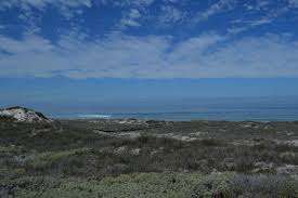
Jakkalsfontein lies inland in the Western Cape, situated between small farming towns and open plains. The area features gently rolling hills and fertile soil, supporting local agriculture, and is accessed via regional roads connecting it to larger centres in the region.
History of Jakkalsfontein
The name Jakkalsfontein dates from the 1690s when farms along the West Coast road were first given names. The earliest source is a report from 1804, when Jakkalsfontein was set aside by the government for the breeding of sheep. for wool.
Previously, the farm was one of the stops on the old road between Cape Town and Saldanha Bay. It took a soldier three days to walk the long distance through his region to deliver mail. The area is known as the Slagtersveld, where elephants, lions, leopards, and wild dogs used to roam freely.
There is a beautiful 1844 Victorian-era map of Jakkalsfontein in the Cape archives. It is hand-drawn on cartridge paper and backed with cheesecloth. The piece of work was never signed but has been well preserved. It shows all the farms in the area, such as Yzerfontein, Tygerfontein, Modder River, Rondeberg and of course Jakkalsfontein.
The area was mostly government-owned and leased to butchers who supplied the settlers with meat. However, by 1844, many farms were in private hands.
In 1898, 5 small salt pans were discovered on Jakkalsfontein by Okkert, a Hottentot who worked on the farm. Salt was a valuable commodity used by fishermen, tanners and butchers.
The postcode for Jakkalsfontein is 7345
Resources
Practical information for the Western Cape, Regulations, permits and helpful tips. See the Colourdots coastal and nature use guide
WEATHER IN JAKKALSFONTEIN TODAY
Browse businesses and places to visit in Jakkalsfontein

Useful Numbers in Jakkalsfontein
Residents and visitors can find important local contact numbers below, including police, medical services, utilities, and community facilities
-
Emergency Services
- Police: Darling 022 492 2314
- Fire: 022 4822996
- Ambulance:10177
-
Medical
- Closest hospital: Darling Clinic 022 492 2626
- Pharmacy;022492 2782
-
Municipal & Utilities
- Water:022 487 9400
- Electricity:022 487 9400
-
Transport & Roads
- Traffic department: Malmesbury 022 487 9400
- Road Emergencies / SANRAL: 0800 204 204
-
Community & Safety
- Childline-116
- SPCA: Swartland 022 492 2781
- 24-hour Poisons Information Helpline of the Western Cape: 0861 555 777.
- NSRI 087 094 9774
-
Local Contacts and Community Resources
- Post office; 022 492 2780
- Library:022 492 2237
Towns in the Swartland district include: Chatsworth; Darling; Grotto Bay; Kalbaskraal; Koringberg; Malmesbury; Moorreesburg; Riebeek kasteel and Yzerfontein;
- Colourdots is an independent regional information resource for the Western Cape.
Learn more about the project HERE