- Province: Western Cape
- Overberg
- Coordinates:34°18′05″S 18°48′59″E
- Area:1.15 km2
- Municipality: Overstrand
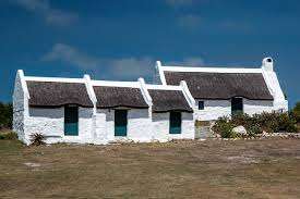
Struisbaai is a coastal town in the Overberg region of the Western Cape, lying just before the R39 south from Bredasdorp. It lies on the southern coastline near Cape Agulhas, at the edge of a wide, open bay. The surrounding area consists of long sandy beaches, large vleis, coastal dunes, and low-lying plains shaped by marine and wind-driven processes.
History of Struisbaai
Over 150 Shipwrecks close to this sleepy fishing village
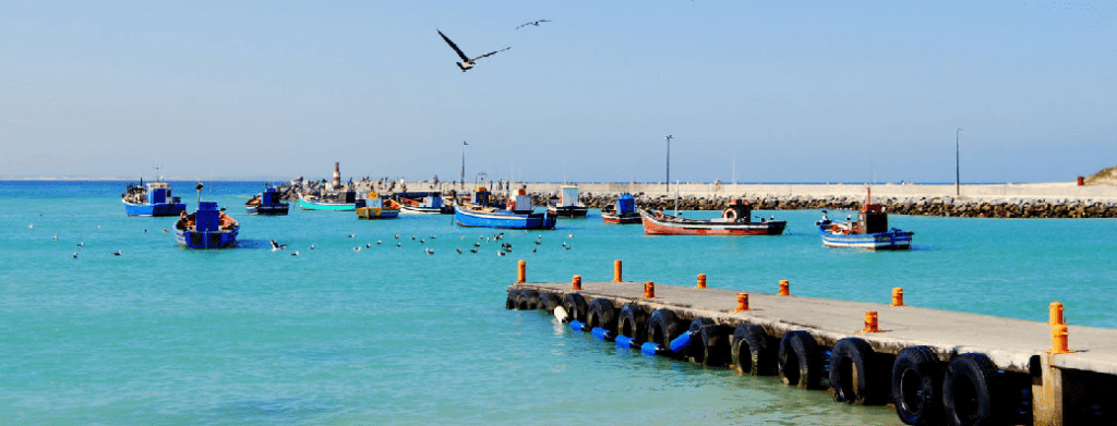
Struisbaai is a historic fishing village with a beautiful natural harbour. Yet the waters surrounding this Southern tip of Africa are treacherous. More than 150 ships are recorded as having been wrecked here. 30 of them have run aground near the beach since 1673. Two, in particular, the Meermin, which was stranded in 1766 when the Malagasy slaves it was transporting mutinied, and the Jardiniere, which sank in 1796. More recently, in 1971, the Liberian oil tanker Wafra ran aground, causing significant oil pollution along the coast before it was eventually towed out to sea and destroyed. In 1974, another oil tanker, the Oriental Pioneer, also ran aground. See a comprehensive list of ships that have wrecked near Struisbaai
The village is surrounded by several large vleis, such as Zoetendal and Kardrivier. Many species of water birds, including flamingos, inhabit these marsh areas. Fishing at Struisbaai is good all year round.

Where does the name come from?
The origin of the name is debated. Three possibilities have been put forward: a) The name is from the straw used for cottage roofs, b) It is after the ostriches, which were in the area (Struisvogel) in Dutch, or c) Struis derived from an old Dutch word meaning huge, referring to the long stretches of beach. Struisbaai is the longest beach in the Southern Hemisphere, stretching for a total of 14 kilometres.
Before 1950, the only buildings were a boarding house and a small shop. Holiday homes began appearing after 1950, and as the settlement grew, running water, a motel, and rondavels were introduced.
When the Cape Agulhas lighthouse was being restored, the village’s name was accepted by the National Names Commission. The new harbour was built in 1959 and expanded in 1990.
The postcode in Struisbaai is 7285 Streets and Boxes, and the licence plate prefix is CS
local WEATHER TODAY
Browse businesses and places to visit in Struisbaai
Things to see and do in Struisbaai
- Tourist Information: Accommodation, Short Videos of the area, Gift Shop, Curios, Souvenirs, and Marine Aquarium are at the tourist office,1 Main Road, Struisbaai
- The Beach has Blue Flag status and is 14 km long.
- Kayak, board, sail and kite sail, walk on the long stretch of beach and collect shells, or safely swim in the ocean
- The annual Geelstertfees (Yellowtail Festival) celebrates the local fishing industry with food stalls and live entertainment.
- Koppie Alleen is where the largest concentration of Southern Right Whales along the South African coast can be seen from July to November. One of the best land-based whale watching look-out points in the world.
- Feed the stingrays. You can buy sardines at the Pelicans Harbour Café, and the stingrays will eat them right out of your hand. The well-known stingray named Parrie has become a popular attraction.
- The De Hoop Whale Trail is the ultimate hiking experience. A 5-day, 54 km trail meanders through the De Hoop Nature Reserve.
- De Mond to Arniston Coastal Trail (4Hours) 11km is a linear trail that takes you along a beautiful coastal route past the Waenhuiskrans cave, and historical fish traps
- De Mond Nature Reserve, between Arniston and Struisbaai, is a Ramsar site
- Fishing at the De Mond Nature Reserve
- There is a bi-annual art route where visitors see local art and artists 028 435 6700
- De Hoop Whale Trail
- Birdwatching, particularly seabirds and flamingoes
- Ghost trail
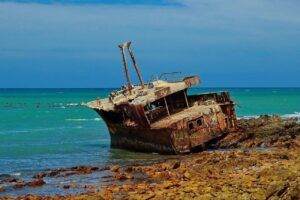
- See the wreck of the Glory May on the beach
Resources
Practical information for the Western Cape: regulations, permits, and helpful tips. See the Colourdots coastal and nature use guide

Useful Numbers
Residents and visitors can find important local contact numbers below, including police, medical services, utilities, and community facilities
-
Emergency Services
- Police: 028 435 6440
- Fire: Bredasdorp): 028 425 1690
- Ambulance: 10177
-
Medical
- Closest hospital: Provincial Hospital (Bredasdorp): (028) 424 1167
- Pharmacy;028 435 6913
-
Municipal & Utilities
- Municipality;028 435 6538
- Water:028 435 6538
- Electricity:028 435 6538
-
Transport & Roads
- Road Emergencies / SANRAL: 0800 204 204
- Traffic department: Bredasdorp Traffic Department – 028 425 5500
-
Community & Safety
- NSRI 087 094 9774
- Childline -116
- 24-hour Poisons Information Helpline of the Western Cape: 0861 555 777.
- SPCA: Animal Welfare (Bredasdorp): 082 898 0787 / (028) 425 227
-
Local Contacts and Community Resources
- Cape Agulhas Tourism: 028 425 5581/ 028 425 5582
- Post office; Postal agency – aqw028 435 6871
- Library: 028 435 6538 028 435 6538 (ask for library)
-
Schools in Struisbaai
- : Primary School-028 435 6062
Other towns and suburbs in the Overstrand area include: Birkenhead; De Kelders; Elim; Fisherhaven; Franskraalstrand; Gansbaai; Hawston; Hermanus; Kleinbaai; Kleinmond; Pringle Bay; and Rooi Els;
Getting to Struisbaai, Directions
from Cape Town. Take the N2 towards Somerset West. Pass through Grabouw and Caledon. Pass the Greyton/Genadenal turnoff R406 to the left. About 4km past this turnoff is the first turn to your right going into Caledon. Ignore this and keep straight on the N2. After about 1km, take the second turn to the right ( Hoop Street and the R316). Pass through Caledon towards Napier and continue straight towards Bredasdorp. Continue through town till you reach a stop street at Recreation Road. Take the road that shows the Struisbaai turn to your right. This is the R319 to Struisbaai.
- Colourdots is an independent regional information resource for the Western Cape.
Learn more about the project HERE
Updated ebruary 2026