- Province: Western Cape
- Garden Route
- Coordinates:34°03′S 23°22′E
- Area:39.7 km2
- Municipality: Bitou
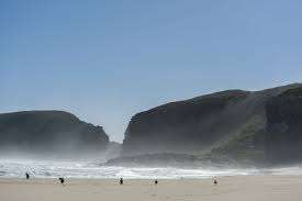
Plettenberg Bay is a coastal town on the Garden Route of the Western Cape, about 520 km east of Cape Town along the N2. It lies between Keurbooms River and Robberg Peninsula, with the Tsitsikamma foothills inland. The town forms part of the Bitou municipal area and provides access to beaches, river estuaries, nature reserves and routes toward Knysna and Nature’s Valley.
History of Plettenberg Bay
There is evidence of human occupation dating back more than 100,000 years. Archaeological sites such as Nelson Bay Cave on the Robberg Peninsula and Matjies River Rock Shelter near Keurboomstrand show continuous use from the Middle Stone Age through the Later Stone Age. Stone tools, ornaments, and food remains associated with early hunter-gatherer communities have been found.
Bahia das Alagoas and shipwrecks
Portuguese explorers charted this area in the 15th and 16th centuries. When Bartholomew Dias found the sea route between Europe and Asia. He called what is now Plettenberg Bay “Bahia das Alagoas”, meaning “Bay of the Lagoons.” He named Robberg “Cabo Talhado”, meaning “Sharp Cape. Manuel da Perestrello arrived 90 years later and called it Bahia Formosa, meaning “Beautiful Bay”
The first Europeans in the area were shipwrecked sailors from the São Gonçalo, which sank on its way back from India. 100 sailors survived, and in Piesang Valley, they managed to build two boats using wood from the forests, with which they eventually managed to sail out. One of the boats reached Mozambique, while the other encountered a passing ship, the São Ignatius Loyola, which was on its way back to Portugal. Sadly, this ship did not reach Portugal because it wrecked in the Bay of Lisbon with much loss of life. They left a stone monument to the shipwreck on which was inscribed in Portuguese, “Here was lost the ship São Gonçalo in the year 1630”.
A stone marker left on Beacon Island by the survivors was later removed and is now housed in the Iziko South African Museum in Cape Town.
The first Europeans to settle in the bay were stock farmers, hunters, and frontiersmen who travelled up from the Western Cape. The bay was given different names by Portuguese sailors, such as Baia de la Goa, Angra das Alagoas (for the marshy lagoons), Baia São Catharina, and Baia Formosa. The Dutch also gave it various names, such as Content Bay, Keurbooms Bay, and Pisang River Bay.
During the early 19th century, Plettenberg Bay functioned as an occasional anchorage and stopping place for ships, particularly during winter voyages along the coast. A woodcutter’s post was established in 1787 when Johann Jacob Jerling was commissioned by the Dutch East India Co. to build a timber storehouse. The first load was exported by De Meermin in August 1788. This building has been partially restored; it still stands today and has been made a National Monument.
Forestry
There were great forests in the area consisting of stinkwood, yellow wood, sneeze wood, ironwood, and other massive trees. Woodsmen would fell them manually and cut them into planks using hand saws.
The timber was transported by sea, with the logs being loaded aboard the ships by oxen. Logs were also transported to Cape Town by wagon.
Whaling
The Dutch East India Company started commercial whaling in South Africa at the start of the 18th Century and opened it up to investors. An English merchant, John Murray, started controlling the whaling industry in the area. Plettenberg Bay was one of six places identified nationally for whaling, and the industry flourished. In 1910, Captain Sinclair set up the whaling station on Beacon Island to harvest the placid Southern Right whales, but this operation ceased in 1916.
These whales would yield more oil and whalebone, which was an essential component of Victorian corsets. In the nineteenth century, a southern right whale would net around three times as much as a humpback whale. This led to a decline in the southern right population by the time whaling was halted.
Devastating fires
Because of the timber trade, Thomas Bain was commissioned to build Prince Alfred Pass and a 90 km road between Tsitsikamma and Humansdorp. The building was made easier by the Great Fire of 1869, which has gone down in the records as possibly the most devastating and terrifying event of the time. However, history was repeated in 2017, in what is now called the “Great Fire”; perfect weather conditions came together, creating a huge fire that swept through both Knysna and Plettenberg Bay in June of that year.
During the Apartheid era, Plettenberg Bay was predominantly a white area with informal settlements of Xhosa migrants around the edges of New Horizons and in the area of KwaNokuthula, which became a town. KwaNokuthula is home to a varied number of ethnic groups, and it is a Xhosa word meaning “place of peace”.
Joachim Ammema Baron van Plettenberg.
Van Plettenberg was born in Leeuwarden, the Netherlands. He studied law at Utrecht and joined the service of the Dutch East India Company, which sent him to Batavia in 1764. In 1766, he was sent as an Independent Fiscal to the Cape, and he was promoted to Secunde and then to Governor in 1774. There was a war with the British during the time he was Governor, and reinforcements were sent from France. Van Plettenberg took great interest in exploring the colony, but there was some discontent about his administration, and an inquiry was held in Holland. He retired in 1785 and lived the rest of his days in Zwolle. He died in 1793.
The license plate prefix for Plettenberg Bay is CX, and the postcode is 6600
WEATHER IN PLETTENBERG BAY TODAY
Browse businesses and places to visit in Plettenberg Bay
Things to do and see in Plettenberg Bay
- Fountainshack trail
- Bloukrans pass
- The ship’s pot and anchor from the Jane can be seen on a farm near Keurbooms River. The ship’s bell, engraved with the name, was used by the church in Piesang River
- Drive along Beachyhead Drive, discover one of the most scenic coastal roadways along the Garden Route.
- Plett ARTS Festival is held in June
- Urban Trail around Plett
- The Dutch Reformed Church at Wittedrif was built in 1843. There is a cannon from an unknown wreck on the property
- Some large iron cauldrons from the whaling industry can be seen on Beacon Island.
- Artefacts from the shipwrecked crew of the São Goncalo are kept in the municipal offices
- Stanley Island Wine and Olive Festival is usually held at Easter time, 073 201 8699. Take a scenic ferry ride across the Keurbooms Lagoon or cruise over in your own boat to this exclusive island venue.
For permits, fishing rules, shell collecting regulations and other practical outdoor information relevant to Plettenberg Bay see the Colourdots coastal and nature use guide

Useful Numbers in Plettenberg Bay
Emergency Services
- Police: 044 501 1900
- Traffic department:044 501 3240 / 3251
- Fire: 0445013230 / 044 533 5000
- Ambulance: 10177
- Medical
- Closest hospital; Mediclinic -044 501 5100
- Community Health Centre-044 501 3700
- Pharmacy; Robberg Pharmacy-044 501 4630
Municipal & Utilities
- Municipality – 044 501 3174/5
- Water:044 501 3122
- Electricity:044 501 3000
Transport & Roads
- Traffic department:044 501 3240 / 3251
Community & Safety
- NSRI: 082 990 5975
- SPCA: PAWS Plett Animal Welfare Service-083 287
Local Contacts and Community Resources in xxx
- Home affairs: 081 070 0020
- Post office;044 533 1260
- Library:044 501 3128
- Local Newspaper Knysna Plett Herald 044 382 1185
- Tourism Plettenberg Bay 044 533 0965
Schools in Plettenberg Bay
Plettenberg Bay Primary School-044 533 2126
Greenwood Bay College-044 533 2549
Formosa Primary School-044 533 1621
Bahia Formosa Primary School-044 533 1498
Plett Pre Primary School-044 533 2542
Plettenbergbaai Secondary School-044 533 0472
GBC Primary and High School-044 533 2549
Raphaeli Waldorf School-044 533 6157
Plettenberg Bay Christian School-044 533 2394
Phakamisani Primary School-044 533 3029
Murray High School-044 533 3193
Die Sterreweg-044 533 2639
Wittedrift High School-044 535 9731
Kwanokuthula Primary-044 533 1626
Kranshoek Primary School- 044 533 9357
Harkerville Ek Primary School-044 535 7703
Municipal facilities in Plettenberg Bay
- Piesang Community Town Hall: 044 501 3360 /078 144 0029
- New Horizon Community Hall:044 501 3000/0788201724
- Bicycle Shelter Community Hall:044 501 3000/078 646 2030
- Green Valley Community Hall:044 501 3452
- Kranshoek community hall:044 501 3314/078 164 6732
- Kranshoek sports field: 044 501 3314
- Plettenberg Bay rugby field:044 501 3328/081 436 6213
- New Horizon Sport field:044 501 3000/084 405 2005
Other towns and suburbs in the Bitou district include: Harkerville: Keurbooms River; Keurboomstrand: Kranshoek; Kurland village; Natures Valley; and Wittedrift;
Getting Around Plettenberg Bay – FAQs
1. Is Plettenberg Bay walkable?
Only partially. The town’s layout is spread out along the coast, and most areas require a car to reach. The central area near Main Street offers some walkability to shops, cafés, and restaurants.
2. Do I need a car in Plettenberg Bay?
Yes. Most travellers find a car essential for reaching beaches, nature reserves, and attractions located outside the town centre.
3. Is public transport available in Plettenberg Bay?
Public transport is very limited. There are taxis, private shuttles, and seasonal e-hailing options, but services are not frequent or comprehensive.
4. Are there buses to and from Plettenberg Bay?
Yes. Long-distance buses connect Plettenberg Bay to cities like Cape Town, Knysna, and Port Elizabeth, but local routes within town are minimal.
5. Are taxis or e-hailing services available?
Yes. Local taxis and ride-hailing services operate, though availability and prices vary. It’s best to arrange rides in advance, especially at night or in off-peak seasons.
6. Does Plettenberg Bay have any shuttle services?
During the summer peak season, a free local shuttle sometimes operates between main attractions and beaches, but it’s temporary and not available year-round.
7. Can I explore Plettenberg Bay by bicycle?
Yes, especially for leisure rides. The area offers scenic mountain biking trails and some coastal routes, though bike lanes in town are limited.
8. Is it safe to cycle in Plettenberg Bay?
Yes, but cyclists should use caution. Roads can be narrow and busy, and the terrain is often hilly. E-bikes are a popular option to make cycling easier.
9. Is the town centre accessible on foot from the beaches?
In some areas, yes. From Central Beach, it’s possible to walk to parts of the town centre, but other beaches and accommodation areas are too far to walk comfortably.
10. What’s the best way to get around Plettenberg Bay?
A rental car provides the most convenience, flexibility, and access to nearby attractions like Robberg Nature Reserve, Keurbooms, and Tsitsikamma.
- Colourdots is an independent regional information resource for the Western Cape.
Learn more about the project HERE