- Province: Western Cape
- District: Garden Route/ Klein Karoo
- Coordinates:33°35′S 22°12′E
- Area: 37.6 km2
- Municipality: Oudtshoorn
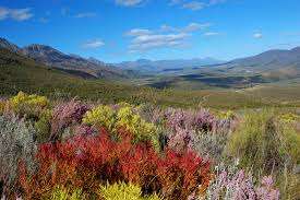
Oudtshoorn is a town in the Little Karoo of the Western Cape, situated about 420 km east of Cape Town and 60 km north of George. It lies along the N12 and near the Swartberg Mountains, making it a gateway to the Cango Caves and surrounding ostrich farms. The town forms part of the Oudtshoorn municipal area and offers access to schools, healthcare, transport routes, and regional attractions in the Little Karoo. Oudtshoorn has an average of 320 days of sunshine every year.
History of Oudtshoorn
Klein Karoo farming town
The first Europeans in the little Karroo were a party of traders led by Ensign Shrijver. They were shown the Elephant trail in 1689 by a Griqua guide, but the area was only settled about 100 years later.
Farmers settled in the Oudtshoorn area in the 1750s, and farming was well established there by the end of the century. Produce consisted of livestock, wheat, barley, tobacco, and some fruit. By the 1830s, subsistence farming in the area had become a successful market economy, which laid a foundation for more development.
The church as the centre of social life
A Dutch Reformed Church in the area, on a part of the farm Hartebeesrivier belonging to Cornelis P. Rademeyer, became the centre of social and congregational life for the next 40 years. By 1847, CP Rademeyer requested permission from the Cape Government to build a town on his farm. 500 residential stands were measured out. This town was originally called Velskoendorp. It was subsequently named after Baron Pieter van Rheede van Oudtshoorn, who was appointed Governor of the Cape Colony by the Dutch East India Company; unfortunately, he died at sea in 1772 before he ever reached Cape Town.
A stopover between the mountains.
This town was originally founded due to the need for a central service area between the Swartberg and the Outeniqua mountains. Previously, the area fell under the Swellendam authority. By 1855, the area had grown so substantially that Colonel A.B. Armstrong was sent to be the first resident magistrate. Oudtshoorn was proclaimed as a magisterial district in 1858. That year, some British settlers arrived in the area as well. The Dutch Reformed Church in Oudtshoorn was established in 1853. The feather industry also attracted a large Jewish community to Oudtshoorn. At the peak of the boom, there were at least 300 Jewish families in Oudtshoorn
Water availability controls development.
The growth of the settlement was limited only by the supply of water. Many irrigation innovations stem from water scarcity. The first necessary barrels of water were delivered for sixpence a barrel.
The year 1859 brought an extended period of drought, broken only in 1869 by floods, when it became possible for farmers to become prosperous again.
The ostriches of Oudtshoorn
Ostriches have been part of the Klein Karoo landscape for centuries, but it was during the mid-1800s that farmers around Oudtshoorn began domesticating the birds for their valuable feathers. Rising international demand, particularly from European fashion houses, transformed the local economy and established Oudtshoorn as the centre of the world’s ostrich industry. Faced with competition from other ostrich-producing regions such as California, local farmers focused on breeding superior birds and producing the highest-quality feathers. By the late 19th century, ostrich feathers were one of South Africa’s most valuable exports, bringing great wealth to the region and earning Oudtshoorn the title of the “Feather Capital of the World”. Many fortunes were made during the feather boom, and the grand Victorian mansions known as “feather palaces” remain a reminder of this prosperous era. The industry eventually declined as fashions changed and the First World War disrupted international trade, but ostrich farming remains an important part of Oudtshoorn’s economy and tourism industry today.
Oudtshoorn is included in Route 62, the world’s longest wine route and is home to a couple of wine farms
The postcodes in Oudtshoorn are 6625(Streets) and 6620 (Boxes). The licence plate prefix is CG
wEATHER IN OUDTSHOORN TODAY
Browse businesses and places to visit in OUDTSHOORN
Things to do and see in Oudtshoorn
- Provincial heritage site– Mimosa Lodge, 85 Baron van Rheede Street
- CJ Langenhoven Museum
- Cango caves
- Suspension bridge– Constructed by Rowley and Sons in London, it was suspended over the Grobbelaars River in 1913, linking the fashionable residential area of Westbank with the centre of town. There is a magnificent view of the Swartberg Mountain from the bridge.
- The Klein Karoo Nasionale Kunstefees (KKNK) is a national arts festival with a focus on the Afrikaans language in performing arts. It is held annually in Oudtshoorn for eight days at Easter time.
- Swartberg Pass, between Oudtshoorn and Prince Albert, an over-the-Swartberg counterpart of Meiringspoort, with 1:7 gradients on narrow, untarred roads, characterised by precipitous hairpins.
- Brakpoort pass
- Droekloof pass
- 36 one MTB challenge
- Eseljagspoort pass
- Rust-en-Vrede Waterfall, R328, 8km outside Oudtshoorn en route to the Cango Caves,
- There are a couple of local vineyards to visit
- Attakwas One day MTB race https://www.atta.co.za
- Dust 4 Glory challenge
- Attakwas Extreme
- The Leopard Crawl offers 3 mountain bike routes https://www.entryninja.com/events/77157-leopard-crawl
- Klein Karoo Klassique
- The OudtshoornScale RC event is one of the most anticipated events on the radio control flying calendar yearly. Held in September
- Veldskoen shuffle, a 90-minute, 2,8km Walk with a local guide, see some Ostrich Feather Palaces and hear local stories. 082 4618253 starts at the local tourism office.
- https://www.oudtshoorninfo.com/.
- Sunshine Simplicities slideshow
Resources
Practical information for the Western Cape: regulations, permits, and helpful tips. See the Colourdots coastal and nature use guide

Useful Numbers in Oudtshoorn
Residents and visitors can find important local contact numbers below, including police, medical services, utilities, and community facilities in and around
-
Emergency Services
- Police: 044 203 9014
- Fire: 044 203 3000
- Ambulance: 10177 044 272 2526
-
Medical
- Closest state hospital: 044 203 7317.
- Klein Karoo Mediclinic: 044 272 0111
- Bongolethu clinic 044 274 0929
- Pharmacy; Watson and Brink. 044 272 2184
-
Municipal & Utilities
- Municipality:044 203 3000
- Water: 044 203 3000
- Electricity:044 203 3000
-
Transport & Roads
- Traffic department: 044 203 3910
-
Community & Safety
- NSRI 087 094 9774
- SPCA: 044 279 1850
-
Local Contacts and Community Resources
- Home affairs: 044 203 7700 / 7701
- Post office; 044 279 1777
- Library: 044 203 3928
- Schoemanspoort Cultural Centre: (044) 279 1766
- Local newspaper: Oudtshoorn Courant 044 272 8918
- Museum; CP Nel museum 044 272 7306
- CJ Langenhovenmuseum 044 272 2968
- Tourism -044 279 2532 https://www.oudtshoorn.com/
-
Schools in Oudtshoorn
- Oudshoorn high: 044 279 1623
- Van Reede Primary School 044 272 2845
- Langenhoven Gimnasium 044 272 2151
Interesting small towns in the Oudtshoorn district include Dysseldorp, De Rust and Volmoed
- Colourdots is an independent regional information resource for the Western Cape.
Learn more about the project HERE