- Province: Western Cape
- District: Garden Route
- Coordinates:34°00′S 23°27′E
- Area:9.75 km2
- Municipality: Bitou
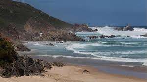
Keurboomstrand lies about 10 km east of Plettenberg Bay along the Garden Route coast. The settlement sits close to the mouth of the Keurbooms River, where the river enters the Indian Ocean. The surrounding landscape includes coastal dunes, indigenous forest and protected areas such as the nearby Keurbooms River Nature Reserve.
History of Keurboomstrand
The name “Keurboomstrand” comes from the Keurboom tree (Virgilia oroboides), which is native to the region and admired for its beautiful pink-purple flowers. This seaside village is known for its pristine, unspoiled beaches, which stretch for kilometres along the Indian Ocean, with great views and a quiet environment.
The Matjes River Rock Shelter, located in the region, has significant historical value with Bushmen artefacts dating back to the Neolithic period, around 11,000 years ago. Stone tools, shell middens and hearth remains show that early coastal communities made use of the rich marine resources of the area. The site provided valuable insight into early hunter-gatherer communities along the southern Cape coast
In 1630, the Portuguese ship São Gonçalo was wrecked near Keurboomstrand. The surviving crew was marooned for eight months, marking the first European settlement in South Africa
. The area is perfect for outdoor enthusiasts, offering a range of activities such as hiking, beach walks, birdwatching, and water sports like kayaking and swimming. The nearby Keurbooms River provides opportunities for boating and fishing, and the surrounding forests and fynbos-covered hills offer scenic trails for hiking and exploring.
The Bitou and Keurbooms Rivers meet here to form a calm lagoon near Keurbooms Beach. The sheltered waters are popular for swimming, although strong currents can occur at the river mouth. Visitors can explore the Keurbooms River by boat or canoe, either independently or on a guided motorboat tour

Things to see and do in Keurboomstrand
- Cathedral rock sacred site
- Fishing in the river
- Keurbooms Lagoon
- Hiking
- . Boats and canoes can be hired from the local angling club.076 670 6500 or www.plettboathire.co.za
Resources
Practical information for the Western Cape, regulations, permits and helpful tips. See the Colourdots coastal and nature use guide
WEATHER IN KEURBOOMSTRAND TODAY
Browse businesses and places to visit in Keurboomstrand
 Useful Numbers
Residents and visitors can find important local contact numbers below, including police, medical services, utilities, and community facilities
-
Emergency Services
- Police: 044 501 1900
- Fire: 044 533 5000
- Ambulance: 10177
-
Medical
- Closest hospital: Mediclinic Plettenberg Bay- 044 501 5100
- Pharmacy;Robberg Pharmacy-044 501 4630
-
Municipal & Utilities
- Municipality – 044 501 3000
- Water: 044 501 3174/5 or 086 124 8686
- Electricity:044 501 3000
-
Transport & Roads
- Traffic department:044 501 3240 / 3251
- Road Emergencies / SANRAL: 0800 204 204
- Childline-116
-
Community & Safety
- 24 hour Poisons Information Helpline of the Western Cape: 0861 555 777.
- NSRI 087 094 9774
- SPCA: PAWS Plett Animal Welfare Service-083 287 9917
-
Local Contacts and Community Resources
- Post office;044 533 1260
- Library: New Horizons Public Library-044 501 3128
Other towns and suburbs in the Bitou district include; Harkerville, Keurbooms River, Kranshoek, Kurland village, Natures Valley, Plettenberg Bay and Wittedrift.
- Colourdots is an independent regional information resource for the Western Cape.
Learn more about the project HERE