- Province: Western Cape
- Coordinates : 33°49′57″S 18°38′51″E
- Area: 2.62 km2
- Municipality: City of Cape Town
The postcode for Durbanville is 7550
Transport
Durbanville is served by Golden Arrow Bus Services and minibus taxis. See linked pages for details. Other options for getting around the Western Cape.
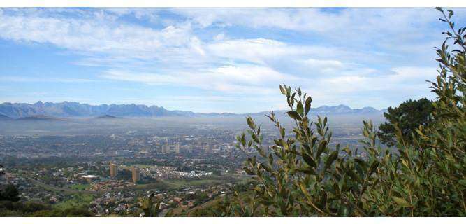
Things to See and Do in Durbanville
- Rust-en-Vrede, in Wellington Road, is a Cape Dutch complex that dates back to 1850
- There are 12 farms in the valley. See a list with contact numbers
- Historical buildings, walking among the remnants of its rich history, several notable structures stand as testaments to Durbanville’s architectural heritage. These buildings not only reflect the town’s evolution but also serve as educational landmarks that provide insight into the region’s past. A walking tour through these sites offers a unique opportunity to appreciate the blend of historical significance and modern development that characterises Durbanville today. Visitors are encouraged to explore these treasures to fully grasp the town’s enduring legacy. With the rapid expansion and modernisation of Durbanville during the early 1900s, the town lost many of its historical buildings; some have remained and are well worth visiting.
- ‘Open gardens’ in spring info@durbanvillegardenclub.co.za
- Durbanville Plaasfees 082 376 3236
- Heritage Square in Vrede St.
- The Durbanville Wine Tram. Hop-On, Hop-Off 082 759 2274
- Thrift shops in Durbanville
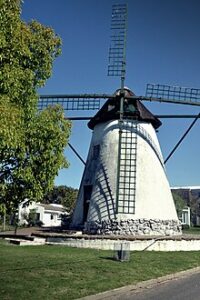
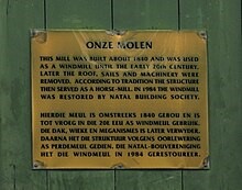
- Onze Molen. The mill was built between 1837 and 1842 at the Johannesfontein farm. The structure was converted to a horse mill. It is one of only two tower mills erected in the Malmesburg district.
- Morningstar Park Outdoor Gym, Cnr School Street and Kwartel Road.
- Vissershoek pass
- The Brews and Blues Festival. It is an annual event. The festival brings together the love of beer and music.
- Tygerberg/Durbanville Nature Reserve
- Boland Dam, Sonstraal and Vygeboom Dams, and Kenridge Dam
- Kenridge Bark Park Door De Kraal Ave. Enclosed off-leash dog park
- Parkrun 08:00 every Saturday at Meerendal Estate, durbanville@parkrun.com
- What’s on in Durbanville, Facebook page
- Durbanville wine safari
- What’s on in Durbanville website
Resources
- For permits, fishing rules, shell collecting regulations and other practical outdoor information, see the Colourdots coastal and nature use guide
local WEATHER TODAY
Browse businesses and places to visit in Durbanville

Useful Numbers in Durbanville
Residents and visitors can find important local contact numbers below, including police, medical services, utilities, and community facilities
-
Emergency Services
- Police: 021 970 3800
- Fire: 021 444 7290
- Ambulance: 10177 – Resq Medix Ambulance Service-021 948 8091
-
Medical
- Closest hospital: Mediclinic 021 980 2100
- Pharmacy; Medicare Pharmacy Village Square-021 975 6570
-
Municipal & Utilities
- Municipality– 021 444 5467
- Water: 021 444 5467
- Electricity: 021 444 5467
-
Transport & Roads
- Traffic department: 021 444 7084
- Road Emergencies / SANRAL: 0800 204 204
-
Community & Safety
- SPCA: Uitsig Animal Rescue,· Animal shelter-083 375 3606
- NSRI 087 094 9774
- 24-hour Poisons Information Helpline of the Western Cape: 0861 555 777.
-
Local Contacts and Community Resources
- Post office; 021 976 2933
- Library;021 444 7070
- Civic centre:021 400 3966
- Museum; Rust-en-Vrede,Art Gallery & Clay Museum- 021 976 4691
-
Schools in Durbanville
- High School-021 976 3188
- Reddam House -010 060 4236
- Fairmont High School, Durbanville-021 976 1147
- Curro Independent School-021 975 6377
- Primary School-021 976 8115
- High School-021 976 3188
- Preparatory School-021 975 1125
- Alpha Primary School-021 976 1493
- Valmary Park Preprimary School-021 976 2890
- Alpha Primary School-021 976 1493
- Kenridge Primary School 021 976 3046
Suburbs in Durbanville include Aurora, Durbanville Hills, Durbell, D’Urbnvale, Durmonte, Eversdal, Goedemoed, Kenridge, Sonstraal, Skoongesig, Uitzicht, Vierlanden and Vygeboom.
FAQs – Durbanville
1. Where is Durbanville located?
Durbanville is a northern suburb of Cape Town, about 30 minutes from the city centre, bordered by Bellville, Brackenfell, and the Durbanville Hills wine region.
2. What is Durbanville known for?
It’s known for its wine estates, leafy upmarket suburbs, and village atmosphere, with easy access to both city amenities and countryside tranquillity.
3. How far is Durbanville from Cape Town?
Durbanville is roughly 30 km from Cape Town CBD via the N1 or N7 highways.
4. What are the main attractions?
Top attractions include the Durbanville Wine Valley, Durbanville Rose Garden, Wine Estates, and Durbanville Nature Reserve.
5. Are there schools in Durbanville?
Yes, Durbanville has several top-rated schools such as Durbanville High School, Durbanville Primary, Fairmont High, and Reddam House Durbanville.
6. What shopping options are available?
Durbanville offers multiple centres, including Village Square, Wellington Park, Wellington Road (High Street shopping) and The Market at the Barn for local produce and crafts.
7. Is Durbanville safe?
It’s considered one of the safer suburbs in Cape Town, with active community patrols and well-established neighbourhood watch groups.
- Colourdots is an independent regional information resource for the Western Cape.
Learn more about the project HERE