- Province: Western Cape
- West Coast
- Coordinates: 32°42′S 18°29′E
- Area: 1.63 km2
- Municipality: Bergrivier
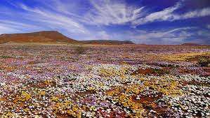
Aurora is a small village in the Western Cape, located inland from the West Coast between Piketberg and Velddrif. It lies in a rural farming area surrounded by low hills and open countryside, about 180 km north of Cape Town. The village is accessed via regional roads linking it to nearby towns such as Redelinghuys, Eendekuil;, and Piketberg, and is known for its seasonal wildflowers and clear night skies.
History of Aurora
Aurora is the Roman goddess of dawn. The small hamlet, however, was named after Ceylonia Aurora Perreira, the daughter of the first Dutch Reformed minister in the area. The village was established on 316 acres on the farm Klipfontein in 1906. It originated as a new Dutch Reformed Parish.
The French astronomer-geodesist, Abbé Nicolas de le Caille, set up an observatory in the area. With his findings, he concluded that the Earth was pear-shaped. The actual shape of the Earth, however, is still in dispute. Visitors are treated to the sight of spectacular night skies for stargazing, and the area is particularly beautiful in flower season from August to October.
The postal code for Aurora is 7325. Boxes only
local WEATHER TODAY
Browse businesses and places to visit in Aurora
Things to see and do in Aurora
- The Sandveld skou. September 022 783 1821 velddrif@bergriviertourism.co.za
- The annual Om-Die-Berg 55km cycle race, 074 143 5200
- The homestead on the farm St Helenasfontein is a historical monument.
- A fully restored Sandveld home on the farm Kapteinskloof is now a guest house.
- On the farm, Rietvlei is the first school built in the area. Children have been taught here since 1875.
- On the farm, Klipfontein is the northernmost beacon used in 1751 by Abbe Le Caille to measure the southern arc of the meridian. The easternmost is in Riebeek West, and the Southernmost is at the corner of Strand and Adderley streets in Cape Town.
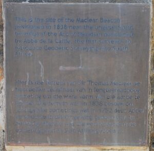
- The English portion of the inscription reads: “This is the site of the Maclear Beacon positioned in 1838 near the original North Terminal of the Arc of Meridian positioned by Abbé de Lacaille, the first surveyor to introduce Geodetic Surveying into South Africa.” Open the image to see the Afrikaans portion.
- Aurora is 51 km from Citrusdal and 45 km from Picketberg
Resources
- For permits, fishing rules, shell collecting regulations and other practical outdoor information, see the Colourdots coastal and nature use guide

Useful Numbers
Residents and visitors can find important local contact numbers below, including police, medical services, utilities, and community facilities in and around Aurora
-
Emergency Services
- Police: 10177 022/ 9312187 Porterville
- Fire: Vredenberg 022 713 1815
- Ambulance: 0227134590 10177
-
Medical
- Closest hospital: Vredenburg 022 713 4136
-
Municipal & Utilities
- Municipality: 022 952 1720
- General emergency: after hours – 083 272 4131
- Water: 022 952 1720
- Electricity: 022 952 1720
-
Transport & Roads
- Traffic department: 022 913 2372
- Road Emergencies / SANRAL: 0800 204 204
-
Community & Safety
- NSRI 087 094 9774
- 24-hour Poisons Information Helpline of the Western Cape: 0861 555 777.
-
Local Contacts and Community Resources
- Post office; Postnet Langebaan 022 772 1338
- Library: 022 952 1720
-
Schools in Aurora
- Primary school 022 952 1674
High school 022 952 1660
Other towns in the Berg River municipality include: Eendekuil; Dwaskersbos; Goedverwacht and Porterville
- Colourdots is an independent regional information resource for the Western Cape.
Learn more about the project HERE