- Province: Western Cape
- District: Cape Winelands
- Coordinates: 33°48′20″S 18°52′11″E
- Area:1.76 km2
- Municipality: Stellenbosch
Jump to:History of Klapmuts |Things to see and do in Klapmuts |Useful Numbers in Klapmuts
Klapmuts is a small town in the Cape Winelands, Western Cape, situated about 30 km northeast of Cape Town, between Durbanville and Paarl. It lies along the R302 and is surrounded by vineyards and agricultural land. The town is known for its rural setting, local wine estates, and proximity to the Tygerberg Hills.
History of Klapmuts
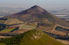
Abraham Gabbema, the local bailiff, named the area “De Clapmats“(a style of sailor’s cap with a flap), likely from the shape of the hill. It was later simplified to Klapmuts.
Archaeological evidence shows that the area around Klapmuts has been inhabited for thousands of years, with Early and Middle Stone Age tools discovered on Klapmutskop. The modern settlement developed around the railway station in the late 1800s and early 1900s, where a lock-up and convict station provided labour for railway construction. Historically, the community consisted largely of farm labourers, railway workers, and other disadvantaged residents, and today only a few historic buildings remain, including the Klapmuts Hotel, built by the Ward family in the late 1880s, which became a
famous stopover for travellers. There are also several houses dating from the 1930s.
The Klapmuts hill is surrounded by wine farms. It consists of sandstone, granite, and shale conglomerate. The vegetation that thrives on this soil type is predominantly the threatened Swaartland shale renosterveld fynbos variety. At the top of the hill, there is geological evidence of an Afrotemperate forest, which consisted of Breede River Yellowwood trees. A conservancy was set up in 2004, and the area’s plants and wildlife are now protected.
The postcode for is 7625
Transport
Klapmuts is served by Metrorail and minibus taxis. See linked pages for details. Other options for getting around the Western Cape.
Things to see and do in Klapmuts
- Visit some of the many wine farms in the area
- Klapmutskop Conservancy was established in 2004 as part of Cape Nature’s Stewardship Programme
- Old Station Complex with Old(Victorian style) Hotel, Old Catholic Church and other
Station Structures
Resources
Practical information for the Western Cape: regulations, permits, and helpful tips. See the Colourdots coastal and nature use guide
local WEATHER TODAY
Browse businesses and places to visit in Klapmuts

Useful Numbers in Klapmuts
Residents and visitors can find important local contact numbers below, including police, medical services, utilities, and community facilities in and around
-
Emergency Services
- Police: 021 875 8000
- Fire: Stellenbosch-021 808 8888
- Ambulance: 10177
-
Medical
- Clinic-021 875 5206
-
Municipal & Utilities
- Water:021 808 8215 / 021 808 8953 / 021 808 8343
- Electricity:021 808 8215 / 021 808 8953 / 021 808 8343
-
Transport & Roads
- Traffic department: Stellenbosch-021 808 8800
-
Community & Safety
- SPCA: Paarl-021 863 2720
-
Local Contacts and Community Resources
- Museum: Afrikaans Taal museum 021 872 3441
- Post office; Agency-021 875 5335
- Library:021 808 8398
-
Schools in Klapmuts
- : Primary School-021 875 5471
- Colourdots is an independent regional information resource for the Western Cape.
Learn more about the project HERE