-
- Province: Western Cape
- Coordinates 33.951°S 18.554°E
- Area 3.55 km2
- Municipality City of Cape Town
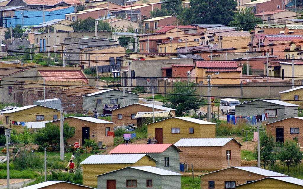
Bonteheuwel, often called “Bontas” by the locals, is a suburb on the Cape Flats in Cape Town, located south-east of the city centre and west of Langa. It lies between Thornton, Pinelands and Gugulethu, with easy access to the N2 and M7 road networks. The suburb forms part of the City of Cape Town metropolitan area and is situated close to industrial zones and major transport routes linking the northern and southern suburbs.
History of Bonteheuwel
Bonteheuwel is a former Coloured township which was established in the 1960s as a new home for the victims of the Group Areas Act of 1950, particularly those forcibly removed from District Six. The name means “spotted hill” in Afrikaans, reflecting the area’s diverse community.
This development was part of a broader strategy to control urban growth and enforce racial segregation.
The area was first intended to be a letting scheme owned by the then Cape Town City. The construction of housing began in 1961 and was completed in 1964.
The housing profile is dominated by brick houses on separate stands, in which 72% of the population live. Then there are semi-detached houses in which a further 11% of the inhabitants live. Backyard dwellings – both brick and informal structures are home to a further 11% of the people.
Bonteheuwel’s Freedom Square has been declared a Provincial Heritage Site in recognition of its historical importance. Located in the suburb’s central business district, the square served as a key gathering place during the anti-apartheid struggle. It was regularly used for meetings, organising, and community mobilisation. The surrounding Bonteheuwel Civic Centre, library, staircases, and raised platforms functioned as informal assembly points, allowing activists to address and engage with the community.
Transport
Metrorail, Golden Arrow Bus Services, and minibus taxis serve Bonteheuwel. See linked pages for details—other options for getting around the Western Cape.
The buses have a Bonteheuwel route, with stops along Bonteheuwel Avenue. There’s a Cape Town route, an Elsies River route, and a Hanover Park route,
The postcodes for Bonteheuwel are 7764 (streets) and 7763 (boxes)
WEATHER IN BONTEHEUWEL TODAY
Browse businesses and places to visit in Bonteheuwel

Useful Numbers in Bonteheuwel
Residents and visitors can find important local contact numbers below, including police, medical services, utilities, and community facilities
-
Emergency Services
- Police: 021 695 4258
- Fire: Epping Fire Department 021 534 1387
- Ambulance: 10177
-
Medical
- Closest hospital: Vanguard Community Health Centre: 021 695 8238
- Pharmacy;
-
Municipal & Utilities
- Water: 021 546 3452 / 0860 103 33089
- Electricity: 0860 103 33089
-
Transport & Roads
- Traffic department: Elsies River 021 592 1158
- Road Emergencies / SANRAL: 0800 204 204
-
Community & Safety
- NSRI 087 094 9774
- SPCA: Grassy Park 021 700 4140
- 24hour Poisons Information Helpline of the Western Cape: 0861 555 777.
-
Local Contacts and Community Resources
- Post office; 021 694 4712
- Library: 021 444 0140
- Civic Centre/Multi-purpose centre/community centre:021 444 051
- Civic Centre /
- Bluegum community centre /
- Community centre /
- Multi-purpose centre.:021 444 0516
- Kalksteenfontein community centre:021 444 0916
- Schools in Bonteheuwel
- Bonteheuwel secondary school : 021 694 4645
- Janari Primary School 021 694 5361
- Rosewood Primary School 087 077 0319
- Arcadia Senior Sekondere Skool 021 694 1736
- Bonteheuwel Sekondere Skool 021 694 4654
- Modderdam Sekondere Skool 021 100 3926
- Protea Primary School 021 694 7799
- Klipfontein Primere Skool 021 370 0161
- Mimosa Primary School 021 694 7808
- Nerina Primary School 021 694 1005
- Arcadia Primary School 021 694 4661
- Bramble Way Primary School 081 732 5081
- Boundary Primary School 084 696 8592
- Cedar Primary School 061 116 9137
- Central Park Primary School 021 694 4659
- Disa Primary School 021 694 2205
- Colourdots is an independent regional information resource for the Western Cape.
Learn more about the project HERE