- Province: Western Cape
- Coordinates; 33°55′50″S “18°26′50″E
- Area; 4.54 km2
- Municipality: City of Cape Town
Woodstock is an inner-city suburb of Cape Town in the Western Cape, about 3 km east of the city centre. It lies between Salt River. and Observatory at the foot of Devil’s Peak, with access via Victoria Road and the N1 and N2 highways. The suburb forms part of the City of Cape Town municipality and is close to the harbour, the CBD and major transport routes.
History of Woodstock
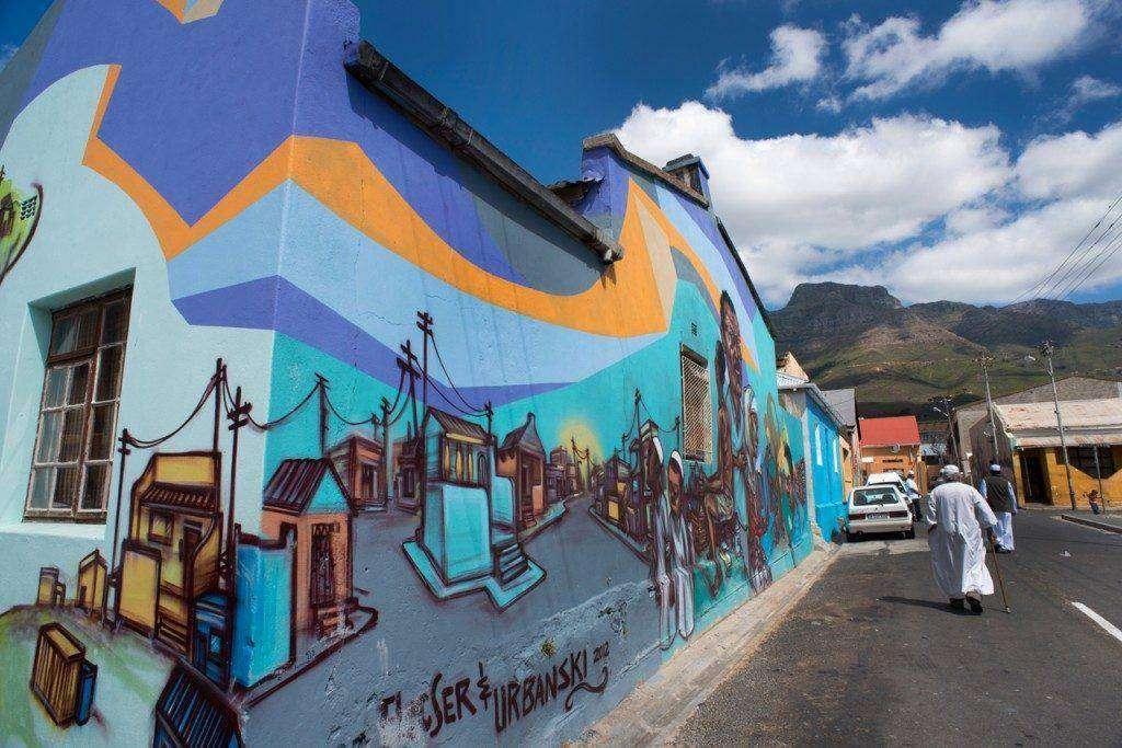
Woodstock is one of the earliest suburbs of Cape Town, between the docks of Table Bay and the lower slopes of Devil’s Peak, about 1 kilometre east of the city centre. There has been some gentrification in recent years, transforming the area from an industrial zone with a somewhat questionable reputation. Woodstock is now one of the city’s most vibrant, hipster neighbourhoods with a vibrant mix of cultures, markets, street art and interesting stores.
Tollgate
The Woodstock Tollgate, historically known as Het Tolhuis (“The Toll House”), was established during the Dutch period as a toll collection point for travellers and traders entering and leaving Cape Town. Strategically positioned near what is now the Victoria Road and Searle Street area, it marked one of the main access routes to the city. The system continued under British rule after 1806. It was part of the colonial road network and revenue system. Over time, the surrounding area developed into a busy transit zone.
By the late 19th and early 20th centuries, the area around the tollgate had also developed a reputation as an entertainment district, with bars, lodging houses, and establishments that catered to sailors and travellers passing through the port city.
Naming of the suburb
The suburb, previously called Papendorp, was named after Pieter van Papendorp, who settled there in the mid-1800s. In the years following, several people built their homes near the Van Papendorp homestead. For a time, it was known as Albert Road; the name was later changed to New Brighton after the British Occupation of the Cape, due to its location near the beach. The area grew, and by the 1860s, it became quite a fashionable seaside suburb.
The suburb was later amalgamated with neighbouring Salt River. The story has it that a meeting was held at the Woodstock Hotel. Here, residents were to propose a new name for the suburb. A group of inebriated fishermen put forward the name Woodstock after their favourite pub. Because they made up the greatest number present, the motion was passed.
The proposed railway line, advertised in 1859 as South Africa’s first, was set to pass through the area. This spurred rapid growth in Woodstock, as speculators seized the opportunity. By 1881, the hamlets of Papendorp, Altona, Roodebloem, Woodstock, Leliebloem, Salt River, and nearby residences were consolidated into a single municipality. Officially incorporated under Act 45 of 1882. The Municipality of Woodstock was established in August 1883.
During this time, the area became a fashionable seaside bathing resort with the beachfront and beachfront cottages just North of the Castle. The area underwent significant industrial and urban development. By 1884, Woodstock had grown into the colony’s third-largest town and was fully self-sufficient.
Beachfront resort
Woodstock used to have a wide sandy beach stretching towards Milnerton. The area between Woodstock Beach and the Victoria & Alfred Docks was a shallow bay called Roggebaai. When land was reclaimed to create the Foreshore, most of the Woodstock beach was lost. In 1968, construction began on the Ben Schoeman Container Terminal, which was completed in 1977, removing the last traces of the shoreline.
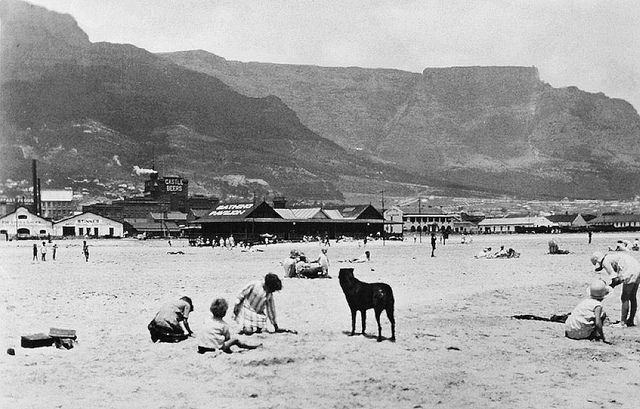
Woodstock beach 1930s
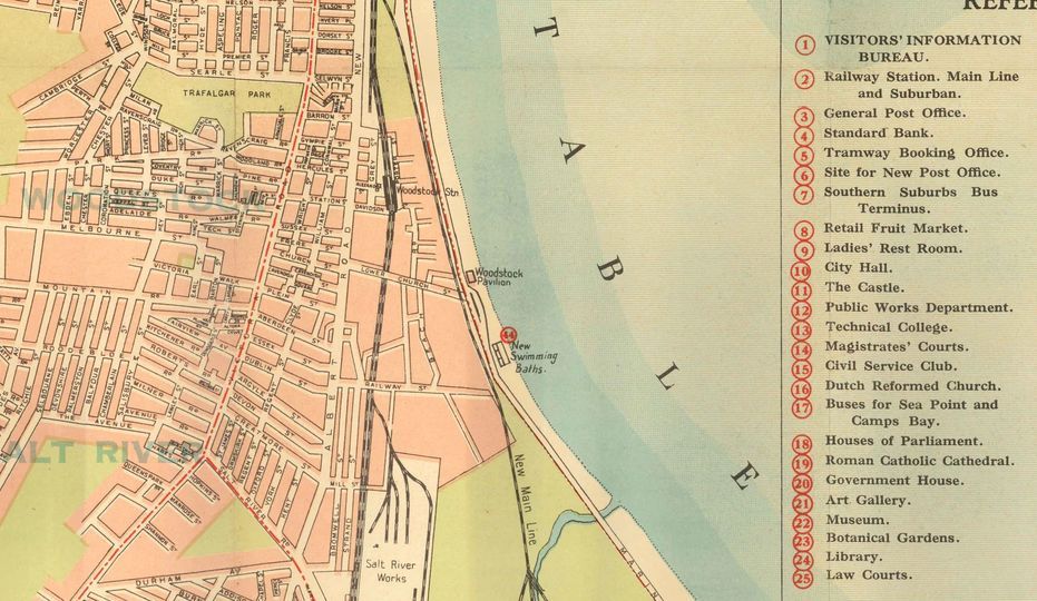
Woodstock map, mid-1930s pre-foreshore reclamation
By 1903, the area had changed somewhat from residential to industrial when there was a great demand for supplies for the British troops during the two Anglo-Boer wars. The first glass in South Africa was manufactured at the Woodstock Glass Factory in 1879.
The lower parts of Woodstock became somewhat rundown after 1950, but the area has recently undergone some gentrification and renewal.
The postal code for Woodstock is 7925 (streets) and 7915 (boxes)
Transport
Woodstock is served by Metrorail MyCiTi Bus, Golden Arrow Bus Services, and minibus taxis. See linked pages for details. Other options for getting around the Western Cape.
Things to do and see in Woodstock:
- The Old Biscuit Mill in Albert Road holds a market every Saturday
- The Bromwell Boutique Mall 250 Albert Rd, Tel: 021 447 4730
- The Ruth Prowse School of Art is housed in the original Roodebloem farmhouse
- The King’s, Queen’s, and Prince of Wales’ blockhouses on Devil’s Peak.
- The Woodstock Foundry, 160 Albert Road,
- Trafalgar Park,
- The Treaty Tree
- The Old Castle Brewery.
- Take a walking tour that promotes “start-ups” in the area
- The Greek Orthodox Cathedral of St George.
- Free Walmer Estate/Woodstock walking tour
- Woodstock Peace Garden
- The Woodstock Exchange creative hub
- Local Graffiti
- Thrift shops in Woodstock
- Local Bookshops
- Take a train to Kenilworth with an amusing educational soundtrack
- See more details of things to see and do
For permits, fishing rules, regulations and other practical outdoor information relevant to Woodstock, see the Colourdots coastal and nature use guide
local WEATHER TODAY
Browse businesses and places to visit in Woodstock
 Useful Numbers in Woodstock
-
Emergency Services
- Police: 021 442 3117
- Fire: 021 444 0830 ape own central`
- Ambulance: 10177
- Medical
- Closest hospital; Cape Town Mediclinic 086 122 4466
- Community Health Centre-021 447 2844
- Pharmacy;Medi-Place Pharmacy-021 447 6871
- Christian Barnard Hospital 021 441 0000
- Municipal & Utilities
- Water:0860 103 089
- Electricity: 0860 103 089
- Transport & Roads
- Traffic Department: Gallows Hill Traffic Department-0860 103 089
- Road Emergencies / SANRAL: 0800 204 204
- Community & Safety
- SPCA: Cape of Good Hope 021 700 4140
- Childline South Africa: 116
- Local Contacts and Community Resources in Woodstock
- Post office: 021 447 2475
- Library:021 444 6867
- Community Hall: 021 447 0252
- Residents association: committee@woodstock.org.za
- Museums and art galleries
- Handsome Fukka Studios-073 453 0077
- Studio Grob-083 256 1170
- Juma art tours-073 400 4064
- Alex Hamilton Gallery & Art Studio-021 447 2396
- Schools in Woodstock
- Alpha School-021 447 1212
- Mountain Road Primary School-021 447 5246
- Queen’s Park High School-021 448 1997
- St Agnes Dominican Convent Primary School-021 447 2839
- Find a comprehensive list of Cape Town Emergency numbers HERE
- The City of Cape Town Public Emergency Communication Centre is available 24/7 For all life or property-threatening emergencies. call 021 480 7700 from any phone or 107 from a landline or report online at https://bit.ly/3o4Ji3K
FAQs – Woodstock
1. Where is Woodstock located?
Woodstock lies just east of Cape Town’s city centre, between District Six and Salt River, along Victoria Road and Albert Road.
2. What is Woodstock known for?
It’s known for its mix of historic buildings, creative studios, and street art, as well as popular markets like The Old Biscuit Mill.
3. How far is Woodstock from the Cape Town CBD?
Woodstock is only about 2 km from the city centre, making it one of the most centrally located suburbs in Cape Town.
4. What type of area is it?
Woodstock is a revitalised urban suburb, with renovated Victorian homes, art galleries, cafés, and office spaces in converted warehouses.
5. Is Woodstock safe?
Like most city areas, safety varies by street. The upper parts of Woodstock are more residential and have active community watch groups.
6. What attractions are in Woodstock?
Highlights include The Old Biscuit Mill, Woodstock Exchange, Woodstock Brewery, and street art tours showcasing local murals.
7. Are there schools in Woodstock?
Yes , including Woodstock Primary School and Holy Cross RC Primary, plus preschools and learning centres nearby.
8. Is there public transport?
Yes, Metrorail trains, MyCiTi buses, and minibus taxis all run through Woodstock with direct routes into the CBD.
9. Is Woodstock pet-friendly?
Many apartments and homes are pet-friendly, though owners should check lease terms. Several cafés also allow pets outdoors.
10. Why visit Woodstock?
Woodstock offers creative energy, proximity to the city, and affordable urban living, making it popular with young professionals and entrepreneurs.
- Colourdots is an independent regional information resource for the Western Cape.
Learn more about the project HERE
Updated October 2025