- Province: Western Cape
- West coast
- Coordinates:31°37′S 18°44′E
- Area:5.99 km2
- Municipality: Matzikama
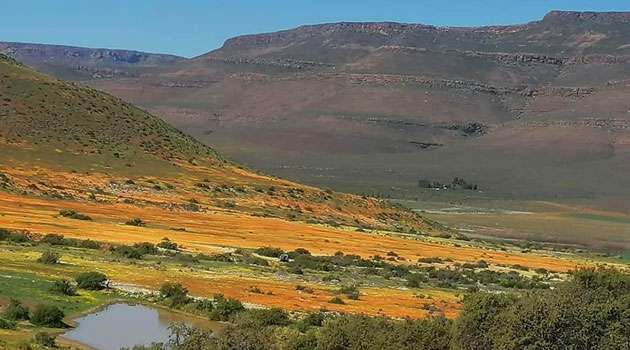
Van Rhynsdorp is a small town in the Western Cape, located in the northern part of the West Coast region. It lies at the edge of the Namaqualand floral area, near the Olifants River. The surrounding landscape consists of semi-arid plains, rocky outcrops, and farmland, with wildflower-covered hills during the spring bloom. Van Rhynsdorp is a gateway to the Namaqualand flower region and lies south of Springbok.
History of Van Rhynsdorp
Early European Exploration
The Knersvlakte area around Van Rhynsdorp was first explored by Europeans in 1661 under the leadership of Pieter van Meerhoff. It was originally known as Trutro (or Troe-Troe). The name is believed to come from the Khoikhoi war cry toro-toro. The Troe-Troe Mission dates back to 1751, when the Trutro Homestead was completed. The building still stands today.
In 1874, the Troe-Troe Mission Congregation was established, and the Troe-Troe homestead was the meeting place for the Dutch Reformed Church’s congregation.
In 1881, the town’s name was changed to Van Rhynsdorp in honour of Reverend Van Rhijn, who played an important role in the church and local community.
Indigenous History
Long before European settlement, the region was home to Khoe pastoralists and San hunter-gatherers. The San lived in the surrounding mountains, and examples of their rock art can still be found in the area today. The Khoe and San communities form part of the earliest known cultural groups in southern Africa.
Like many areas in South Africa, colonial expansion and later apartheid policies led to the displacement of indigenous communities from their land. These historical disruptions had long-term social and economic impacts that are still felt in the region today.
After a few months of British control, on the 20 jan190, during the Anglo-Boer War, Van Rhynsdorp was occupied for a short while by the Boers commanded by JBM Hertzog. The town was reoccupied by the Boers and Jan Smuts on 25 November that year.
The license plate prefix for Van Rhynsdorp is CCP, and the postcode is 8170
Things to do and see in Van Rhynsdorp
- The Gifberg pass
- Tierberg pass
- . Visit the world-famous succulent nurseries
- Van Rhyn Museum and Old Jail
- Discover buildings dating back as far as the 1700s.
- War graves.
- Marble mine/quarry, south of the town. The slabs are cut from marble, 650 million years old, which is cut and processed in Vredendal.
- Gypsum mine. This is the largest in the country and is on the border of the Knersvate.
Resources
Practical information for the Western Cape: regulations, permits, and helpful tips. See the Colourdots coastal and nature use guide
WEATHER IN VAN RHYNSDORP TODAY
Browse businesses and things to see in Van Rhynsdorp

Useful Numbers
Residents and visitors can find important local contact numbers below, including police, medical services, utilities, and community facilities
-
Emergency Services
- Police: 027 219 8031
- Ambulance:10177
-
Medical
- Closest hospital; 027 213 2036 clinic 027 219 1733
- Pharmacy;027 219 2969
-
Municipal & Utilities
- Water: 027 201 3404/3401
- Electricity:082 323 7463
- Municipality; 027 219 1030
-
Transport & Roads
- Traffic department:027 201 3432
- Road Emergencies / SANRAL: 0800 204 204
-
Community & Safety
- NSRI 087 094 9774
- 24 hour Poisons Information Helpline of the Western Cape: 0861 555 777.
- SPCA: Matzikama Dierebeskerming 027 213 4182
-
Local Contacts and Community Resources in
- Post office; 027 219 1460
- Library:0272013466
- Info centre; 027 201 3371
- Tourism; 027 201 3371
-
Museums;
- The old jail 027 219 1048
- Latsky radio museum 4 church st 027 219 1032
-
Schools in Van Rhynsdorp
- Vanrhynsdorp high 027 219 1010
- Maskam primary 027 219 1440
Other towns in the Matzikama district include Bitterfontein; Doringbaai; Ebenhaeser; Klawer; Lutzville and Koekenaap; Strandfontein; and Vredendal
- Colourdots is an independent regional information resource for the Western Cape.
Learn more about the project HERE