History of Hout Bay
- Province; Western Cape
- Coordinates: 34°2′S 18°21′E
- Area; 28.38 km2
- Municipality: City of Cape Town
When the Dutch established a colony at the cape in 1652 they needed timber for ship maintenance, building and fuel. There were no trees to speak of in Table Bay, due to drier conditions and of course the wind. Fortunately, the Southern slopes of Table Mountain were covered in forests. Hout Bay means Wood Bay from the original Dutch name. Jan van Riebeeck gave Hout Bay its current name, “T’ Houtbaaitjen.” The Dutch later constructed a road over Constantia Nek to access the timber-rich valley, and by 1677, the first land was rented for farming in the area.
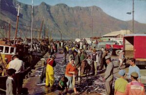
The fishing village was established in about 1867 when Jacob Trautman, a German immigrant, began to fish and farm in the area. It also has a sheltered natural harbour and the area was briefly occupied by the French in 1788. Until the early 50s, this was mainly an agricultural area as the valley was separated from the city bowl by the mountains. The harbour is one of the busiest in the Western Cape. There is a thriving fishing industry, yet the area was only connected to electricity in 1947.
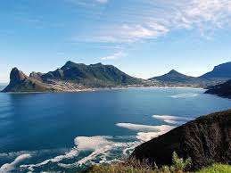
The local beach is flat with white sand about 50 to 100 meters wide which stretches about a kilometre from Chapman’s Peak Drive (M6) in the east to the fishing boat harbour in the west. There is loads of parking. There are lifesavers on duty at this beach where kayaking and kite flying are popular.
Courtesy Cape Town Historical Society Jason Patrick Hanslo

Hout Bay harbour when the fishing boats returned
The postcodes for Hout Bay are 7806 (streets) and 7872 (boxes)
WEATHER IN HOUT BAY TODAY
All listings in hout bay
Things to do and see
- Kronendal Estate
- Chapman’s peak drive
- Hout Bay Common Park Outdoor Gym Bainskloof Road
- Surf at “The Dungeons”
- Grootkop and Judaspeak trail
- Craft market at the docks.
- suikerbossie Sacred Cave and Equinox rocks
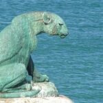
- The bronze leopard of Hout Bay was sculpted by Ivan Mitford-Barberton in 1963. He donated it to the community. The sculpture is a memorial to the wild animals that once freely roamed the peninsula.

- Hout Bay Grailstone.The Grail Stone, on the Constantiaberg, is a triangular rock with a hole in it that captures the setting sun at the summer solstice. The hole is just wide enough to accommodate the movement of the Earth, termed precession, which takes place over 41 000 years.
- Fish and chips at the dockside
- The 4 km Oude skip hike begins at the top of Eustegia road, turn left and walk 2 km along the contour path. You will be able to see the wrecked ship from here. Turn around a return by the same route.
- Hout Bay Parkrun every Saturday at 8.00 am, Ambleside School, 54 Milner Road
Useful Numbers in Hout Bay
- Police: 021 791 9300
- Traffic department: Hill Star 021 444 3811
- Fire: 021 480 7700
- Water:0860 103 089
- Electricity:0860 103 089
- Ambulance: 10177
- Post office; 021 790 1740
- Library: 021 791 7660
- The Hangberg Advice office: 079 044 4292
- Closest hospital; Hout Bay Family Medical Centre 021 790 3120
- Clinic; Harbour Community Health Clinic 021 790 1050
- Recreation centre and civic Centre: 021 400 3647
- SPCA: Animal rescue group-021 790 0283
- Schools: Hout Bay International School 021 791 7900
Ambleside School 021 790 4449
Kronendal primary 021 790 2060
Disa primary school 021 200 0790
Hout Bay High School 021 790 4951
Hout Bay Secondary School 021 790 4951
Oranjekloof mor primary 021 790 3350 - Ratepayers association:021 790 0268 info@houtbayratepayers.co.za
- Hout Bay Recreation centre: 021 790 5673 Karbonkel Road
- Hout bay tourism :021 217910747
Other suburbs along the Atlantic seaboard include: Bantry Bay; Bakoven; Camps Bay; Clifton; Fresnaye; Greenpoint; Llandudno; Mouille Point; Sea Point; and Three Anchor Bay
Close also Imizamu Yethu


