- Province: Western Cape
- District: Overberg
- Coordinates: 34°25′S 20°51′E
- Area: 20.45 km2
- Municipality: Swellendam
Jump to:History of Infanta |Useful Numbers in Infanta
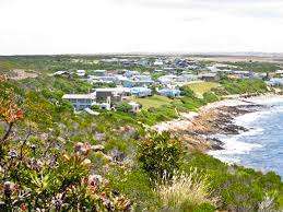
Infanta lies at the mouth of the Breede River in the Overberg region of the Western Cape. The village sits on the southern bank of the estuary opposite Witsand and is surrounded by coastal fynbos and farmland. Its position at the river mouth makes it a well-known destination for fishing, boating, and birdlife.
History of Infanta
The village of Infanta lies at the mouth of the Breede River opposite Witsand, which lies on the opposite bank. It remains undeveloped and attractive to nature lovers and fishermen. In 1488, the Portuguese recognised the Breede River mouth as the finest natural anchorage on the entire Southern coast, and in 1576, King Sebastien’s navigator, Manuel De Mesquita Perestrello, called the bay Dom Sebastiao. The most serene King of Portugal.
The sleepy little settlement was founded in 1819 when there was a severe drought. Joseph Barry (Founder of Infanta) transported rice and maize from Cape Town up into the Breede River mouth. Infanta takes its name from Cape Infanta, which is several km to the south. The cape was in turn named after Captain João Infante, who commanded one of Bartolomeu Dias’s caravels.
In 1800, the Landdrost Anthonie Faure reported to Governor George Young that the Breede River was navigable for up to six hours inland with safe loading for smaller vessels along each bank.
The Malgas pont service began in 1860. If it were not there, you would have to drive all the way to Swellendam to cross the river at the bridge and drive down the other side. It was the last hand-drawn, pulley-operated ‘pont’ in South Africa until recently modernised.
Resources
Practical information for the Western Cape, Regulations, permits and helpful tips. See the Colourdots coastal and nature use guide
WEATHER IN INFANTA TODAY
Browse businesses and places to visit in Infanta

Useful Numbers in Infanta
Residents and visitors can find important local contact numbers below, including police, medical services, utilities, and community facilities
-
Emergency Services
- Police: Swellendam-028 514 8100
- Fire: Bredasdorp-028 425 1690
- Ambulance: 10177
-
Medical
- Closest hospital: 028 425 1690
- Slangrivier Clinic-028 722 2522
- Pharmacy; Protea Swellendam- 028 514 2083
-
Municipal & Utilities
- Municipality Swellendam-028 514 8500
- Water: 028 514 8552
- Electricity:028 514 8500
-
Transport & Roads
- Traffic department:028 514 1185
- Road Emergencies / SANRAL: 0800 204 204
- Childline-116
-
Community & Safety
- 24-hour Poisons Information Helpline of the Western Cape: 0861 555 777.
- NSRI 087 094 9774
- SPCA:028 514 2083
-
Local Contacts and Community Resources
- Post office;028 514 1220
- Library: Closest 028 514 8590-RAILTON PUBLIC LIBRARY
Other towns in the Swellendam district are Barrydale and Suurbraak
- Colourdots is an independent regional information resource for the Western Cape.
Learn more about the project HERE