- Province: Western Cape
- Coordinates: 33°55′58″S “18°27′27″E
- Area: 2.75 km2
- Municipality: City Of Cape Town
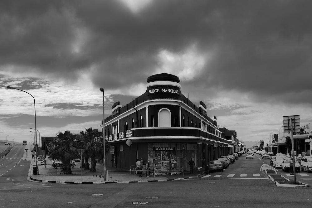
Salt River is an inner-city suburb of Cape Town located just east of the city centre, between Woodstock and Observatory. The area lies along the Liesbeek River and the N1 and N2 highway approaches, making it one of the main transport corridors into the CBD. It forms part of the City of Cape Town metropolitan municipality and is closely connected to neighbouring suburbs such as Maitland and District Six
History of Salt River
Salt River began as a small settlement near the mouth of the Salt River estuary. In 1657, some of the first VOC “free burghers” received permission to farm along the river, while the lower reaches of both the Salt River and the Liesbeek River were extensively fished. Early records from Jan van Riebeeck mention hunting game in the wilderness around the Salt River, Black River, and Diep Rivers.
By 1665, the area consisted of a small inn and several fishermen’s cottages overlooking a fjord-like section of the river. At the time, the Salt River formed part of a vast wetland system of estuary marshes and salt pans stretching across the Cape Flats. Much of this natural wetland area has since been channelled and reclaimed, and today the Salt River is largely a rerouted canal rather than a natural river. Paarden Eiland itself once formed part of this river system before land reclamation altered the coastline.
The river also played an important defensive role in early Cape Town. During winter, it formed a substantial natural barrier, and even in summer, it could still help protect the settlement from attack, including during the slave uprising of 1808.
Salt River began developing rapidly after the railway arrived in 1862, transforming the suburb into a major rail junction and industrial centre. In 1883, Salt River and neighbouring Woodstock were amalgamated into a single municipal area. By the early 1900s, the area had become one of Cape Town’s great industrial boomtowns. The railway industry, steel works, and textile factories all operated here, attracting workers from across the city.
Industrialisation created a huge demand for housing, leading to the construction of rows of small Victorian terraced houses for workers. Many of these single-storey homes with narrow stoeps still survive today along streets with British colonial names.
The old Salt River Power Station was built beside the estuary because seawater could be used for cooling. Salt River 1 became the first coal-fired power station built and operated by Eskom, then known as ESCOM. The station eventually closed in 1979.
During the 1950s and 1960s, many residents from District Six moved to Salt River, even before the full implementation of forced removals under the Group Areas Act. Many Malay and coloured families settled in the suburb because they were permitted to buy property there. Indian residents faced stricter rules and could generally only purchase property if it included a corner grocery shop, which explains why small shops once appeared on almost every street corner in the area.
Salt River is within a Heritage Protection Overlay Zone (HPOZ). This is a Municipal Planning Bylaw pertaining to any changes to building facades. Permission is needed from the City of Cape Town. As most buildings have been there for 60 years or more, a permit is required from Heritage Western Cape for external or internal changes.
Unlike in some other places, street art has to be authorised. The City of Cape Town, the surrounding residents and the owners have to agree on a sketch of the work that is going to be created before it can go ahead
Community house has always been known as a site of activism since the mid 1980s. The building houses NGO’s and Trade Unions, and a labour and community history museum centred on the Trade Union Library and its archive. There are affordable Halls. for hire. 021 447 7319 41 Salt River Rd
The Salt River Cemetery has been there since the late 1800s
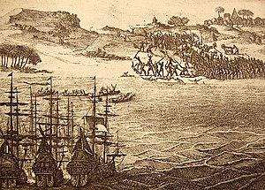
Battle of Salt River
On the 1st of March 1510, a force of around 150 Portuguese armed with swords and spears attacked and raided a local village. A force of 170 locals, along with a herd of cattle, counter-attacked using stones, fire-hardened tipped wooden spears and poison arrows. The locals herded the cattle that they used as shields and achieved victory
The postcode for Salt River is 7925
Transport
Salt River is served by Metrorail, MyCiTi Bus, Golden Arrow Bus Services, and minibus taxis. See linked pages for details. Other options for getting around the Western Cape.
Resources
Practical information for the Western Cape, Regulations, permits and helpful tips. See the Colourdots coastal and nature use guide
WEATHER IN SALT RIVER TODAY
Browse businesses and places to visit in Salt River

.Useful Numbers
Residents and visitors can find important local contact numbers below, including police, medical services, utilities, and community facilities in and around
-
Emergency Services
- Police: SAPS Woodstock-021 442 3117
- Fire: City of Cape Town – Fire Station-021 444 0830
- Ambulance: 10177
-
Medical
- Closest hospital;Groote Schuur Hospital-021 404 9111
- Clinic (Woodstock)Chapel Street Clinic-021 461 7870
- Pharmacy;Medi-Place Pharmacy-021 447 6871
-
Municipal & Utilities
- Water: 0869 103 089
- Electricity: 0869 103 089
- Transport & Roads
- Traffic Department: Elsies River Traffic Department-021 592 115
-
Community & Safety
- NSRI 087 094 9774
- SPCA: Cape Of Good Hope -021 700 4140
-
Local Contacts and Community Resources
- Post office; Woodstock Post Office-021 447 2475
- Library: Woodstock Town Hall and Public Library-021 444 6867
- Community house: 021 447 7319
- Salt River Town hall:021 447 0608
- Salt River Community Hall: 021 400 3647
-
Schools in Salt River
- : Cecil Road Primary School-021 448 1574
- Salt River Secondary School-021 448 1534
- Wesley Practising School-021 448 1646
- Salt River Public School-021 448 1405
- Shereens Montessori-021 447 7810
- B.e.s.T College- special needs-B.e.s.T College- 021 448 5746
- Salt River Muslim Primary School-021 447-9525
- Find a comprehensive list of Cape Town Emergency numbers HERE
- Colourdots is an independent regional information resource for the Western Cape.
Learn more about the project HERE
.