
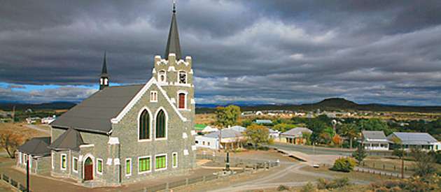
- Province: Western Cape
- Central Karoo
- Coordinates:32°46′25″S 21°58′49″E
- Area:11.5 km2
- Municipality: Prince Albert
Leeuw Gamka is situated in the Great Karoo region of the Western Cape, about 355 kilometres north-east of Cape Town and roughly halfway between Beaufort West and Ladismith along the N1 national road. The town lies near the confluence of the Leeuw and Gamka Rivers, from which it takes its name. Surrounded by semi-arid plains and low hills, the area supports Karoo vegetation and sparse livestock farming. Leeuw-Gamka also functions as a stopover for travellers along the N1, with its modest railway station connecting it to larger regional centres. The town’s elevation is approximately 640 meters above sea level, and it experiences hot, dry summers and cold winters typical of the inland Karoo. Despite its small size, Leeuw-Gamka has basic services and acts as a rural community hub for surrounding farms.
History of Leeuw Gamka
This town is named Lion twice. Leeuw (Lion in Afrikaans) and Gamka (Lion in Khoi). The two rivers in the area are named Leeuw and Gamka, respectively. Hundreds of years ago, before the settlers moved in, the plain was populated with many lions.
However, it is historically recorded as the geographic location where the last wild, free-ranging Cape Lion (Panthera leo melanochaita) was shot and killed in 1842 by explorer Robert Gordon. driving the distinct, black-maned subspecies into absolute extinction.
. The town exists because of the railway line, which reached the area in 1879 and a station was opened. Originally called Fraserberg Road, as the nearest existing station was Fraserberg. A small town developed around the station, with some stone cottages being built for railway workers; also, a hotel and a station building were erected.
Long before the town existed, the legendary father-and-son pass-building team of Thomas and Andrew Geddes Bain mapped out the area. They officially logged the outpost in their journals under the uninviting name “Bitter Water” because the underground water table was highly hydrogenous, salty, and brackish. Despite the taste, it was the only reliable water for miles.
The settlement was an outspan area where travellers could rest. There was “drinkable” water and good grazing. It was a popular spot where explorers, migrant farmers, missionaries, and even outlaws stopped over, camping near a grove of thorn trees at the confluence of the two rivers.
When some diamonds were discovered in Hopetown in 1867 and in Kimberly in 1868, A lot of traffic passed through here. The discovery of gold on the Witwatersrand in 1886 brought another wave of fortune hunters through the area.
The Anglo-Boer War from 1899 brought troop trains of wounded soldiers. The hotel and railwaymen’s houses were converted into a hospital and convalescent wing.
The stone blockhouse on the riverbank was built in 1901 by the British, who were intent on guarding the railway line bridge. The remains of it can be seen today.
The historic Leeu-Gamka Hotel (which dates back to the late 1890s) has a massive, 900-year-old fossilised elephant tusk proudly on display. It was dug out of the dry alluvial silt of the Gamka River bed, proving the arid Karoo Desert once was home to these huge animals
In 1950, the town and station were officially renamed Leeu-Gamka
The license plate prefix for Leeuw Gamka is CZ, and the postcode is 6950
Things to see and do in Leeuw Gamka
- See the Anglo-Boer War Graves
- The grave of the tallest soldier in the British Army, who stood over seven feet tall. – 5396 Private J Schultz
- -The blockhouse is one of South Africa’s last, still fully functional telephone operator offices
- The huge elephant tusk in the hotel
Resources
Practical information for the Western Cape, regulations, permits and helpful tips. See the Colourdots coastal and nature use guide

Useful Numbers
Residents and visitors can find important local contact numbers below, including police, medical services, utilities, and community facilities
-
Emergency Services
- Police: 023 521 8000
- Fire: Prince Albert; 082 220 0848
- Ambulance:10177
-
Medical
- Closest hospital: 023 521 2124
-
Municipal & Utilities
- Municipality 023 521 2135
- Water: 023 541 1014
- Electricity: 023 541 1014
-
Transport & Roads
- Road Emergencies / SANRAL: 0800 204 204
- Childline-116
-
Community & Safety
- SPCA: Beaufort West Karoo SPCA072 847 7312
- 24-hour Poisons Information Helpline of the Western Cape: 0861 555 777.
- NSRI 087 094 9774
-
Local Contacts and Community Resources
- Post office; post agency 023 521 2001
- Library:023 521 2837
-
Schools in Leeuw Gamka
- Leeuw Gamka Primary 023 521 2049
Towns in the Prince Albert municipality include: Klaarstroom, Prince Albert, and Prince Albert Road
- Colourdots is an independent regional information resource for the Western Cape.
Learn more about the project HERE