- Province: Western Cape
- District: Overberg
- Coordinates; 34.5385° S, 20.0569° E
- Area 25.15 km2
- Municipality: Cape Agulhas
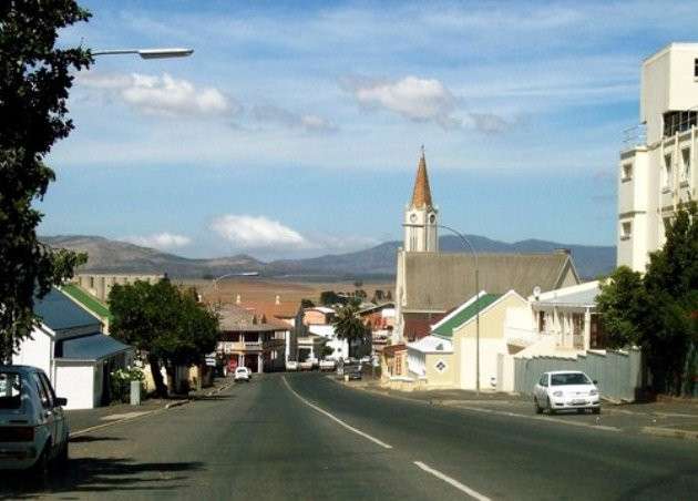
Bredasdorp is situated in the Overberg region of the Western Cape, approximately 160 km southeast of Cape Town. The town lies inland from the southern coastline, near Arniston and the De Hoop Nature Reserve. It serves as a commercial and administrative centre for the surrounding rural farming area, which spans roughly 4,000 square kilometres. The landscape around Bredasdorp includes rolling hills, wheat fields, and indigenous fynbos vegetation, with proximity to wetlands and coastal reserves. The town is accessible via the R317 and R319 roads, connecting it to Napier, Swellendam, and nearby coastal villages.
ump to:History of Bredasdorp |Things to See & Do in Bredasdorp |Useful Numbers in Bredasdorp
History of Bredasdorp
Bredasdorp is one of the two termini of the railway line from Cape Town. The town is the commercial centre for 4000 square kilometres. It was established partly due to a dispute between Michael van Breda and Pieter Voltelyn van der Bijl. They could not agree on the site on which to build a church. Michael van Breda wanted it to be built on his farm, Langefontein, and Pieter Voltelyn van der Bijl wanted it to be built on his own farm, Klipdrift. They could not resolve the dispute, and consequently, two churches were built. One on Langefontein and one on Klipdrift. The church at Klipdrift marked the establishment of the town of Napier. The one on Langefontein became the church for Bredasdorp. It was built between 1838 and 1842, with further expansions done in 1856. (See Napier)
The town was named after Michael van Breda, who introduced Merino sheep to the area when he began farming sheep on his farm, Zoetendals Vallei. (Sweet Valley). The Merino Statue near BNK Landbou on Swellendam Road commemorates his work.
The area is known for wheat production, dairy and wool. Wildflowers are abundant, particularly the red Bredasdorp lily and Elim Hath, which are Indigenous to the area.
In the 1980s, the town developed further with the establishment of the Denel missile test range and the South African Air Force Test Flight and Development Centre near Arniston. The relocation of the Overberg District Council’s head office to the town also contributed to its growth.
The Zoetendal was a Dutch vessel that ran aground in 1673 on the nearby coastline.
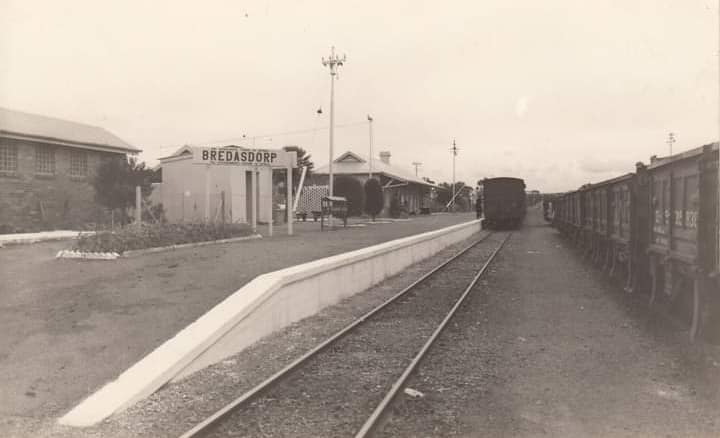
Vintage picture of Bredasdorp station
The postcode is 7280, and the licence plate prefix is CS
local weather today
Browse businesses and places to visit in Bredasdorp
Things to See & Do in Bredasdorp
- –Heuningberg Nature Reserve is tucked away in the hills overlooking the town.
- De Hoop Vlei, 40 kilometres south-east of Bredasdorp in the Western Cape, is the oldest Ramsar wetland in South Africa
- The PE Roux Memorial Garden on the square in Bredasdorp 028 424-1420
- The Dutch Reformed Church, completed in 1911 in Cape-Gothic style, and the Anglican Church, designed by Sophie Gray in 1861
- -The famous Shipwreck Museum was opened in April 1975.
- Go wine tasting at local vineyards
- -short hikes and walks in the nearby mountains
- A self-guided historical walk starts at the tourism offices in the Du Preez Building, which was erected in 1894.
Resources
For permits, fishing, nature use guidelines for the area, regulations and other practical outdoor information relevant to Bredasdorp, see the Colourdots coastal and nature use guide

Useful Numbers in Bredasdorp
Residents and visitors can find important local contact numbers below, including police, medical services, utilities, and community facilities
-
Emergency Services
- Police: 028 425 5400
- Ambulance: 10177
- Fire: 028 425 1690
-
Medical
- Closest hospital; Otto Du Plessis-028 424 2652
- Pharmacy; Primary Healthcare Pharmacy-028 425 1193
-
Municipal & Utilities
- Municipality: 028 425 1157
- Water: 028 425 5599
- Electricity:028 425 5604
-
Transport & Roads
- Traffic department: 028 424 2440
- Road Emergencies / SANRAL: 0800 204 204
-
Community & Safety
- NSRI (Sea Rescue): 087 094 9774
- Childline South Africa: 116
- Poison Information Centre: 0861 555 777
-
Local Contacts and Community Resources in Bredasdorp
- SPCA: Animal Anti-Cruelty League- 082 898 0787
- Home Affairs 028 425 1165
- Post office;028 424 1370
- Library: 028 425 5614 / 15
- Museum; Shipwreck Museum-028 424 1240
- Cape Agulhas Tourism Office: 028 424 2584
-
Schools in Bredasdorp
- Primary School-028 424 1334
- High School-028 424 1210
- De Heide Primary School-028 424 1230
- Albert Myburgh Secondary School-028 425 1517
- Heldersig Koshuis-(028) 424 1210
- Albert Myburgh Senior Secondary School-028 425 1517, 028 424 1689
- DS de Wet School- 082 929 4276
FAQ
Where is Bredasdorp located?
Bredasdorp is in the Overberg region of the Western Cape, about 160 km southeast of Cape Town.
What is Bredasdorp known for?
It is known as a farming town and the gateway to the Cape Agulhas area, featuring historic buildings and local museums.
What facilities are available in Bredasdorp?
There are schools, healthcare facilities, shops, and access to local administrative services.
- Colourdots is an independent regional information resource for the Western Cape.
Learn more about the project HERE