- Province: Western Cape
- Coordinates: 34°2′45″S 18°27′15″E
- Municipality: City of Cape Town
- Area: 2.50 km²
Bergvliet is a suburb in the southern suburbs of Cape Town, Western Cape. It lies about 15 km south of the city centre, bordered by Retreat, Tokai, and Heathfield. The area is primarily residential, with schools, parks, and local shops, and is accessible via Main Road (M4) and the nearby M3 freeway, providing easy connections to the city centre and the southern suburbs.
Jump to: History of Bergvliet | Things to See and Do in Bergvliet | Useful Numbers in Bergvliet
History of Bergvliet
Bergvliet is a quiet residential suburb in Cape Town’s southern suburbs, set against the Constantiaberg mountains. The name means “mountain streamlet” and reflects the area’s agricultural origins.
The suburb formed part of the original Constantia farm owned by Simon van der Stel. The historic Cape Dutch farmhouse, built in 1769, still stands on the western side of Bergvliet and is a declared national monument. The surrounding land once included a small natural spring known as Die Oog, which later became a dam supplying water to the farm.
After World War II, the farm was subdivided to create affordable homes for returning South African servicemen. Most of the suburb was developed during the late 1940s and 1950s, including Bergvliet’s three main schools.
Today, Bergvliet is known for its green spaces, family homes, and easy access to nature. It sits close to Kirstenbosch National Botanical Garden and the Constantia Wine Route, and offers quick access to the M3 highway.
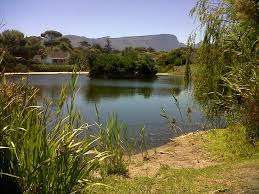
Die Oog Bird Sanctuary is a small but important wetland area in Bergvliet. Originally a natural spring and farm dam, it is now a public open space managed by the City of Cape Town.
The sanctuary provides habitat for ducks, herons, kingfishers, reed cormorants, sacred ibis, hadeda ibis, and is a major roosting site for cattle egrets. It is also a breeding area for the endangered Western Cape leopard toad.
Residents use the paths around Die Oog for walking, jogging, and dog walking. There are ongoing efforts to declare the area a formal nature reserve.
The suburb is bordered by greenbelts and former farmland, including Dreyersdal Farm and nearby wetlands that now form part of a private nature reserve. The suburb has several parks and open spaces.
The postal codes for the area are 7945 (streets) and 7864 (Boxes)
Transport
Bergvliet is served by Golden Arrow Bus Services and minibus taxis. See linked pages for details. Other options for getting around the Western Cape.
local WEATHER TODAY
Browse businesses and places to visit in Bergvliet
Things to See and Do in Bergvliet
- Die Oog Bird Sanctuary, Corner of Lakewood and Midwood Avenues, Cape Town
- Forest walks and mountain trails in the Constantiaberg
- Sports facilities, galleries, and an open-air theatre in the greater Bergvliet area
Resources
Practical information for the Western Cape: regulations, permits, and helpful tips. See the Colourdots coastal and nature use guide

Useful Numbers in Bergvliet
Residents and visitors can find important local contact numbers below, including police, medical services, utilities, and community facilities
-
Emergency Services
- Police: Diep River 021 710 7300
- Fire: Constantia; 021 400 5514
- Ambulance: 1017
-
Medical
- Closest hospital: DP Marais in Retreat 021 713 7600
- Pharmacy; at Spar 021 712 6569
-
Municipal & Utilities
- Water: Constantia 0860 103 089
- Electricity: City power 086 056 2874 Eskom 021 915 9111
-
Transport & Roads
- Traffic department: Ottery 0860 103 089
- Road Emergencies / SANRAL: 0800 204 204
-
Community & Safety
- SPCA: 021 700 4140
- NSRI 087 094 9774
- 24-hour Poisons Information Helpline of the Western Cape: 0861 555 777.
-
Local Contacts and Community Resources
- Ratepayer Association; http://www.bmra.co.za/
- Post office: closest, Tokai 021 712 2314
- Library; Meadowridge 021 712 9382
-
Schools in Bergvliet
- Bergvliet High School, 021 712 0284
- Bergvliet Primary School, 021 715 1103
- Sweet Valley Primary School. 021 712 3081
- Colourdots is an independent regional information resource for the Western Cape.
Learn more about the project HERE