Jump to:
Cape Peninsula | West Coast |The Cederberg |South Coast & Cape Agulhas |Garden Route & Cape Fold Mountains | Karoo
Overview
The rocks and mountains of the Western Cape tell a story that began hundreds of millions of years ago. Ancient oceans deposited layers of sand and mud. Molten rock cooled deep underground, and mountains rose and folded. Wind, water and ice slowly carved the landscape into what we see today.
Learn about the geology that shaped the Western Cape, from the granite outcrops of the Cape Peninsula and the sandstone cliffs of Table Mountain to the folded mountains of the Garden Route and the wide open plains of the Karoo. The Western Cape’s landscapes, dramatic cliffs, unusual rock formations, caves, dunes and mountain ranges all tell the story of how the province was formed.
The geology of the Earth is often described as a history book, with missing pages; much is still being interpreted from the available evidence.
Cape Peninsula
The landscape of the Cape Peninsula is made up of three main rock types formed more than 500 million years ago.
The oldest are the Malmesbury rocks, dark, layered rocks that can still be seen on Signal Hill, Malmesbury and the lower slopes around Cape Town.
These were later intruded by Cape Granite, a hard rock with large pale crystals that form much of the Peninsula’s foundation. Large granite outcrops can be seen at places like Boulders Beach, Bakoven, Chapman’s Peak and Lion’s Head.
Above these is the Table Mountain Group, thick layers of sandstone that created the cliffs and flat mountain tops of the Peninsula. These rocks formed the dramatic scenery of Table Mountain and Cape Point. Small clues within the rock even show evidence of ancient glaciers.
Read more about the Table Mountain Group
West Coast
The West Coast reveals some of the oldest rocks in the Western Cape. Ancient sediments and granite that formed hundreds of millions of years ago remain exposed.
The area also contains raised beaches, limestone, dunes and mineral deposits, including phosphate and gypsum. Coastal winds and changing sea levels continue to shape this landscape today. There are also important mineral deposits, including marine diamonds and heavy mineral sands such as ilmenite, rutile and zircon, formed through long periods of coastal and river erosion. The weathered granite and exposed rock along this coastline help create its rugged character.
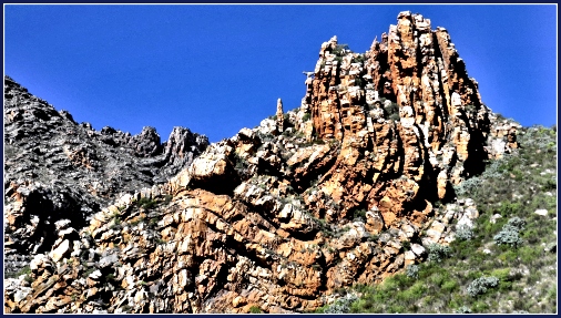
The Cederberg
The Cederberg mountains are made mainly of hard sandstone that formed around 140 million years ago. These rocks are part of the Table Mountain Group, but here they have been deeply shaped by time, weather and erosion.
Over millions of years, wind and rain slowly carved the sandstone into unusual shapes, cliffs and natural arches. Well-known features like the Wolfberg Arch and Maltese Cross are the result of this long process of erosion acting on cracks and weaker layers in the rock.
The Cederberg is also part of a much older geological story. Layers of sand were originally laid down, then compacted into rock over millions of years. Later, tectonic movement lifted these layers and exposed them to weathering.
The result is a dramatic landscape of orange rock formations, deep valleys and open mountain spaces that continue to change slowly over time.
South Coast and Cape Agulhas
Many of the rocks along the coast belong to the ancient Cape Supergroup, deposited more than 400 million years ago when rivers and shallow seas covered this region.
Powerful waves gradually carved cliffs and coastal caves by exploiting cracks in the rock. Wind created the extensive dune systems that still shift and move today.
These geological processes, including the stormy weather, created the landscapes seen around Cape Agulhas, De Hoop and the southern coastline. They are also the reason so many ships have wrecked in the area.
See Shipwrecks around the Western Cape coastline
Garden Route and Cape Fold Mountains
The mountains that define the Garden Route formed when ancient layers of sediment were squeezed and folded around 250–300 million years ago.
This is how the Cape Fold Mountains were formed. These stretch for hundreds of kilometres across the Western Cape.
The Garden Route is separated from the interior Karoo region by these mountain ranges, including the Outeniqua and Swartberg Mountains. Many rivers begin high up in these mountains and flow southwards, helping shape forests, valleys and the coastline.
The folded sandstone layers can be seen clearly along mountain passes and hiking routes throughout the region.
Karoo
Much of this region formed in an ancient inland basin where layers of mud, sand and sediment slowly accumulated over millions of years.
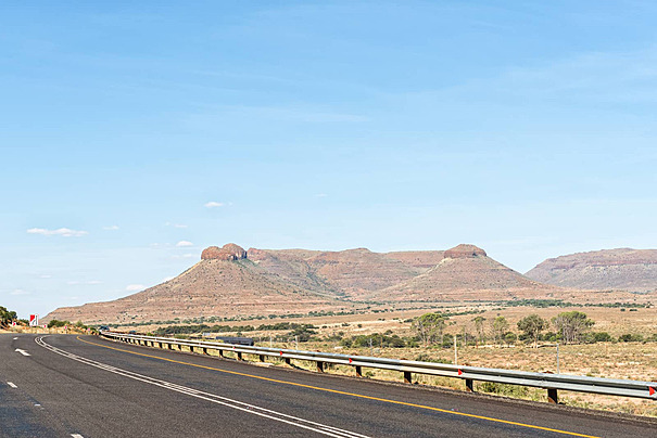
Later, molten rock forced its way upward and cooled underground into hard dolerite. Because dolerite erodes more slowly than the surrounding rock, it formed the flat-topped hills and dramatic cliffs seen across the Karoo today. The alternating layers of sandstone, mudstone and dolerite give the Karoo its distinctive landscape.
To explore how these landscapes were first surveyed and recorded, visit the Mapping Museum in Cape Town.
Interesting Facts About
Western Cape Geology
- Table Mountain once formed part of a much larger mountain range.
- Some Western Cape rocks formed when this region lay beneath ancient seas.
- Evidence of ancient glacial activity can still be found in Western Cape rocks.
- The Cape Fold Mountains once formed part of a larger mountain system connected to land now found in Antarctica and South America.
- The mountains and geology of the Western Cape influence rainfall, vegetation and even where towns developed.
- Back to the top ↑
Colourdots is an independent regional information resource for the Western Cape.
Learn more about the project HERE