- Province: Western Cape
- Coordinates: 33°55′45″S 18°24′15″E
- Area:1.04 km2
- Municipality; City of Cape Town
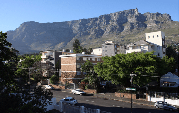
Tamboerskloof is situated on the lower slopes of Signal Hill above Cape Town’s City Bowl in the Western Cape. The suburb lies west of Gardens and east of Sea Point, with direct road connections to the city centre via Kloof Nek Road and Kloof Street. It is bordered by Signal Hill to the north and central Cape Town to the south, forming part of a compact inner-city residential area close to major amenities, transport routes and the Atlantic Seaboard.
Its central location makes Kloof Street’s shops, restaurants, and bars easily accessible. Outdoor enthusiasts can enjoy the Pipe Track hike along Table Mountain with fantastic views over Camps Bay. With its combination of history, culture, scenic beauty, and convenient city access, Tamboerskloof remains a sought-after and vibrant neighbourhood in Cape Town.
History of Tamboerskloof
Tamboerskloof played an important role in supplying passing ships at the Cape. Farms on the mountain slopes around the peninsula grew fresh produce for the settlement and visiting vessels, while lookout posts manned by “spotters” used drums to signal approaching ships.
One of the earliest posts was near present-day Tamboerskloof Tamboer (Drum) + Kloof (Valley), meaning “Valley of the Drums.” In the 1800s, the area included four small farms, Klippenburg, Tamboerskloof, Leeuwenvoet, and De Hoop, which provided food for city residents and passing ships. The original Tamboerskloof farmhouse once stood where the Lord Milner Hotel is today.
Today, it is one of Cape Town’s oldest residential suburbs, known for its eclectic mix of Victorian homes, art deco apartment blocks, villas, and modern houses. Nestled between the City Bowl, Signal Hill, and Lion’s Head, the suburb is somewhat sheltered from the southeasterly Cape Doctor wind.
The postcode for Tamborskloof is 8001
Transport
Tamboerskloof is served by MyCiti Bus, Services, and minibus taxis. See linked pages for details. Other options for getting around the Western Cape.
Resources
Practical information for the Western Cape, Regulations, permits and helpful tips. See the Colourdots coastal and nature use guide
 Useful Numbers
Residents and visitors can find important local contact numbers below, including police, medical services, utilities, and community facilities
-
Emergency Services
- Police: SAPS Cape Town Central – 021 467 8078
- Fire: Central Fire Station & Sentrale Brandweerstasie -021 444 8963
- Ambulance: 1017
-
Medical
- Closest hospital: Mediclinic Cape Town – 021 464 5500
- Pharmacy; Blooms Pharmacy – 021 423 4941
-
Municipal & Utilities
- Water: 0860 103 089
- Electricity:0860 103 089
-
Transport & Roads
- Traffic Department: Gallows Hill Traffic Department – 0860 103 089
- Road Emergencies / SANRAL: 0800 204 204
-
Community & Safety
- SPCA: Cape of Good Hope SPCA -021 700 4140
- NSRI 087 094 9774
- 24-hour Poisons Information Helpline of the Western Cape: 0861 555 777.
-
Local Contacts and Community Resources
- Post office; Mill Street Post Office – 021 465 1013
- Library: Kloof Street Public Library – 021 424 3308
-
Schools in Tamboerskloof
- Tamboerskloof Primary School-021 423 6338
- German International School Cape Town-021 480 3830
- Find a comprehensive list of Cape Town Emergency numbers HERE
- The City of Cape Town Public Emergency Communication Centre is available 24/7 for all life-or-property-threatening emergencies. Call 021 480 7700 from any phone or 107 from a landline or report online at https://bit.ly/3o4Ji3K
- Colourdots is an independent regional information resource for the Western Cape.
Learn more about the project HERE