
The Mapping Museum at the offices of National Geo-spatial Information (NGI) tells the story of how South Africa was measured, mapped, and surveyed over more than 250 years.
The museum houses an impressive collection of historic surveying instruments, including theodolites, measuring chains, early distance-measuring equipment, aerial photography tools, and the famous Tellurometer, a South African invention that revolutionised surveying worldwide.
Early Mapping at the Cape
Although land was being allocated and recorded at the Cape from the time of Jan van Riebeeck, early surveys were often crude and inaccurate. Farms were frequently measured by pacing distances on foot, and maps were assembled from sketches, estimates, and incomplete information.
Accurate scientific surveying only began in the 18th century with the work of French astronomer Abbé Nicolas-Louis de la Caille. Arriving in Cape Town in 1751, he established an observatory in Strand Street and catalogued nearly 10,000 southern stars.
While at the Cape, De la Caille carried out the first geodetic survey in the Southern Hemisphere. By measuring an arc of the Earth’s meridian between Cape Town and the Swartland, he helped advance understanding of the planet’s shape. See Riebeek West and Aurora
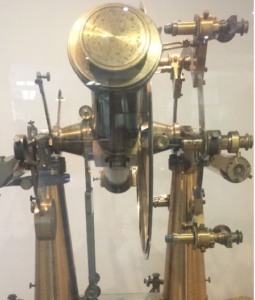
(Image)Great theodolite
Sir Thomas Maclear and the Shape of the Earth
Nearly a century later, Sir Thomas Maclear, Astronomer Royal at the Cape Observatory, revisited De la Caille’s work.
Between 1840 and 1848, Maclear extended and verified the original survey. His measurements proved that the Earth is flattened at both poles and showed that De la Caille’s unexpected results were caused by local gravitational effects rather than an error in the survey itself.
Maclear’s triangulation network stretched from Cape Agulhas into Namaqualand and became the foundation of South Africa’s geodetic survey system. His work also led to landmarks such as Maclear’s Beacon on Table Mountain being named in his honour.
Sir David Gill and the National Survey
Modern mapping in South Africa owes much to Sir David Gill, Astronomer Royal at the Cape from 1879 to 1907.
Recognising the poor quality of existing maps, Gill proposed a comprehensive triangulation network across southern Africa. Working with Colonel William Morris and the Royal Engineers, he established a precise framework of survey points that connected vast areas of the subcontinent.
Their work created the foundation upon which accurate topographic maps, property surveys, engineering projects, and modern geographic information systems would later be built.

(Image) Astronomical theodolite
From Plane Tables to GPS
Early surveyors used plane tables, sextants, chains, and large mechanical theodolites. Some instruments were so heavy that they had to be carried in separate pieces up mountains. The museum illustrates how surveying technology evolved.
During the 20th century, aerial photography dramatically improved map production. South African engineer Dr Trevor Wadley later developed the Tellurometer, the world’s first successful microwave distance-measuring instrument, allowing surveyors to measure long distances quickly and accurately.
Today, satellite technology and GPS have largely replaced traditional methods. South Africa’s modern TrigNet network of continuously operating GNSS stations provides highly accurate positioning data across the country.
(image) stereogonimeter
Visit the Mapping Museum
The museum offers a fascinating glimpse into the science, technology, and determination that shaped South Africa’s maps. Visitors can view instruments used by generations of surveyors and learn how pioneers such as Abbé de la Caille, Sir Thomas Maclear, Sir David Gill, and Colonel Morris helped create one of the most advanced survey systems in the world.