- Province: Western Cape
- Coordinates: 33.9160° S, 18.4721° E
- Area:
- Municipality; City of Cape Town
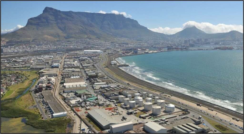
Paarden Eiland is an industrial area located about 6 km north of the Cape Town city centre, between the suburbs of Brooklyn and Milnerton. It lies along the eastern shore of Table Bay at the mouth of the Salt River and is bordered by the N1 freeway and the busy Marine Drive corridor. The area forms part of Cape Town’s older industrial belt and provides easy access to the Port of Cape Town, the central business district, and the northern suburbs. Its location close to major transport routes has made it an important logistics and light-industrial hub within the city
History of Paarden Eiland
Paarden Eiland was originally inhabited by the !Uril’aekua people (Goringhaiqua as the Dutch spelt it)
The battle of Salt River took place here, and it was also the scene of the tragic loss of the Jonge Thomas, where Wolraad Woltemade performed his heroic rescue but drowned in the process.
Paarden Eiland (“Horse Island”) in Dutch was originally a big sand bar surrounded by waterways. The earliest settlers kept their livestock here. It was originally populated with hippos. During the wet winter months, there was just a single point of entry to the rest of the peninsula. The river broke through the sandbar close to where Duncan Dock is today.
Over time, land reclamation projects, especially in the 20th century, altered the natural flow of the Salt River and the Black River. The rivers were canalised, and the estuary was filled in to accommodate urban expansion and industrial activities. The area was drained in the early 20th century to make way for the Culemborg shunting yards and the Salt River Power Station in the 1920s. ( It was declared an industrial area in 1935) It developed rapidly after World War II. Today, the original river mouth has been significantly modified, with much of it rerouted or covered.
The postcodes for Paarden Eiland are 7405 (Streets) and 7420 (Boxes)
Transport
Paarden Island is served by Golden Arrow Bus Services, and minibus taxis. See linked pages for details. Other options for getting around the Western Cape.
Resources
Practical information for the Western Cape, Regulations, permits and helpful tips. See the Colourdots coastal and nature use guide

Useful Numbers in Paarden Eiland
Residents and visitors can find important local contact numbers below, including police, medical services, utilities, and community facilities
-
Emergency Services
- Police: Maitland-021-5069451
- Fire: Brooklyn-021 510 5180
- Ambulance:1017
-
Medical
- Closest hospital/clinic; Brooklyn-Albow Gardens Clinic-021 444 5950
- Pharmacy;Barclay Square Pharmacy-012 341 8072
-
Municipal & Utilities
- Water:0860 103 089
- Electricity:0860 103 089
-
Transport & Roads
- Traffic department:0860 103 089
- Road Emergencies / SANRAL: 0800 204 204
-
Community & Safety
- Childline-116
- 24 hour Poisons Information Helpline of the Western Cape: 0861 555 777.
- NSRI 087 094 9774
- SPCA: Cape Of Good Hope- 021 700 4140
-
Local Contacts and Community Resources
- Post office;021 511 4312
- Library: Brooklyn -021 444 5994
- Find a comprehensive list of Cape Town Emergency numbers HERE
Suburbs adjacent to Paarden Eiland are Brooklyn, Kensington and Salt River
- Colourdots is an independent regional information resource for the Western Cape.
Learn more about the project HERE