Province : Western Cape
Coordinates 33.9121° S, 18.5071° E
Area 1.88 km2
Municipality; City of Cape Town
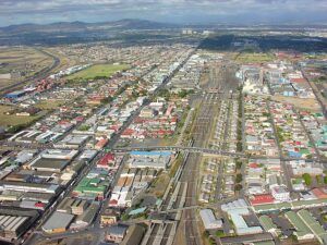
Kensington is a residential suburb located about 8 km north-east of the Cape Town city centre on the western edge of the Cape Flats. The suburb lies between major transport routes, including the N1 highway and the railway line through Maitland, providing easy access to the central city and surrounding industrial areas such as Epping. The terrain is flat and sandy, typical of the Cape Flats, with elevations of roughly 15–20 metres above sea level. Surrounding suburbs include Thornton to the north, Pinelands and Observatory to the east, Brooklyn and Epping Industria to the south, and Factreton and Windermere to the west.
History of Kensington
Kensington developed in the early 1900s as Cape Town expanded beyond the older suburbs around the harbour and city centre. Land that had previously been farmland was subdivided into residential plots, forming what became known as Kensington Estate. Its growth was closely linked to nearby railway lines and industrial areas, which attracted working-class families looking for housing close to employment.
During the 1920s and 1930s, housing shortages led to informal settlements in neighbouring Windermere, which grew into one of the largest squatter communities in Cape Town. Under apartheid legislation, particularly the Group Areas Act, the area was designated mainly for Coloured residents, and many people were forcibly removed to townships such as Nyanga, Gugulethu, and Langa. Over time, formal housing replaced earlier informal settlements, and the suburb developed into the established residential community seen today.
The postcode for Kensington is 7405
Transport
Kensington is served by Golden Arrow Bus Services, and minibus taxis. See linked pages for details. Other options for getting around the Western Cape.
Resources
Practical information for the Western Cape, Regulations, permits and helpful tips. See the Colourdots coastal and nature use guide

Useful Numbers in Kensington
Residents and visitors can find important local contact numbers below, including police, medical services, utilities, and community facilities
-
Emergency Services
- Police: 021 594 7020
- Fire: 021 510 5180
- Ambulance:021 551 2999 (10177)
-
Medical
- Closest hospital; Day Hospital-021 593 1150
- Clinic: Community Health Centre-021 593 1150
- Pharmacy;021 593 8406
-
Municipal & Utilities
- Water:0869 103 089
- Electricity:0869 103 089
-
Transport & Roads
- Traffic department: Goodwood-021 594 7020
- Road Emergencies / SANRAL: 0800 204 204
- Childline-116
-
Community & Safety
- 24-hour Poisons Information Helpline of the Western Cape: 0861 555 777.
- NSRI 087 094 9774
- SPCA: Cape of Good Hope SPCA-021 700 4140
-
Local Contacts and Community Resources
- Post office; Maitland-021 511 3793
- Library;021 400 4345
- Kensington civic centre:021 444 5799
-
Schools in Kensington
- Kensington High School-021 593 3050
- Windermere Primary School-021 593 8264
- Kenmere Primary School-021 593 2300
- St John’s R.C. Primary School-021 593 1960
- Windermere Secondary School-021 593 2550
- H. J. Kroneberg Primary School-021 593 8313
- Hidayatul Islam Primary School-021 593 754
- St John’s Catholic School-021 593 1960
- Kensington High-021 593 3050
- Colourdots is an independent regional information resource for the Western Cape.
Learn more about the project HERE