- Province: Western Cape
- Central Karoo
- Coordinates:32°7′S 23°0′E
- Area:72.04 km2
- Municipality: Beaufort West
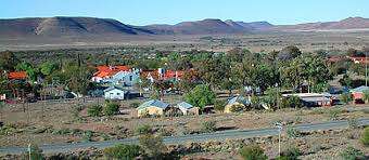
Nelspoort is a small village in the Karoo region of the Western Cape province of South Africa, situated along the N1 between Beaufort Westand Laingsburg. The settlement lies in a semi-arid landscape typical of the Great Karoo, surrounded by low hills and open plains. Nelspoort developed near the Buffels River, a seasonal river that flows through the region. Its location along the major north–south transport route has historically linked the village to nearby Karoo towns and farming areas.
History of Nelspoort
During the 1700s, Trekboers arrived in the Karoo. These were semi-nomadic farmers. They were Afrikaans-speaking migrants. Previously, the land was inhabited by the San people for thousands of years. Evidence of this comes from rock paintings of an animal, long-extinct and identified as Megalotragus of the bovine genus. This dates the paintings to 10,000 years or older.
The town was established when John Molteno, who later became Prime Minister of the Cape Colony, established a farming enterprise by that name. He built a large network of farming estates. The enterprise was geared towards the export of the wool. The area continued as a sheep farming area with the farm Nelpoort at the centre.
In the early 20th century, Nelspoort became known for its sanatorium, established to treat tuberculosis (TB) patients. The dry, warm climate of the Karoo was considered ideal for patients with respiratory conditions. The Nelspoort Sanatorium attracted people from across South Africa seeking treatment and contributed to the town’s growth during that period.
Resources
Practical information for the Western Cape, Regulations, permits and helpful tips. See the Colourdots coastal and nature use guide

Useful Numbers
Residents and visitors can find important local contact numbers below, including police, medical services, utilities, and community facilities
-
Emergency Services
- Police: 023 416 1888
- Fire: 023-4148176 10177
Ambulance:10177 -
Medical
- Closest hospital: 023-4148200
Pharmacy; Nuweveld Pharmacy: 023-4142151 -
Municipal & Utilities
- Municipality– 023-4148100
- Water:023 414 8100
- Electricity: 023 414 8100
-
Transport & Roads
- Traffic Department – 023-4143409
- Road Emergencies / SANRAL: 0800 204 204
-
Community & Safety
- Childline-116
- 24-hour Poisons Information Helpline of the Western Cape: 0861 555 777.
- NSRI 087 094 9774
-
Schools in Nelspoort
- Restvale Met Primary School- 023 416 1648
- Most services are in Beaufort West
Other towns in the Beaufort West Municipality are Merweville and Murraysberg.
- Colourdots is an independent regional information resource for the Western Cape.
Learn more about the project HERE