
History of Lotus River
Province: Western Cape
Coordinates: 34.036°S 18.513°E
Area: 5.01 km2
Municipality; City of Cape Town
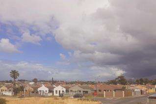
Lotus River is a mixed suburb on the Cape Flats. Here vast tracts of unstable sand dunes were the scene of, large housing projects during the apartheid era, mostly as part of the Nationalist government’s larger effort to force the so-called Coloured community out of the central and western areas of Cape Town, which the political theorists of the day had designated as whites-only areas. The postcode for Lotus river is 7941
WEATHER IN LOTUS RIVER TODAY
all listings in lotus river

Useful Numbers in Lotus River
- Police: Saps Grassy Park-021 700 3900
- Traffic department: Hillstar Traffic Department-0860 103 089
- Fire: Ottery Fire Station-021 444 3500
- Water:0860 103 089
- Electricity:0860 103 089
- Ambulance: 10177
- Lotus River recreation centre:021 706 0146 Cnr 5th Avenue & Buck Road
- Post office;Ottery Post Office-021 704 2209
- Closest hospital; Grassy Park Community Health Clinic-021 707 6300
- Library: Lotus River Public Library-021 444 1361
- Pharmacy;LOTUS River Day Hospital Pharmacy-021 703 3131
- SPCA: 021 700 4140
- Schools: Lotus River Primary School-021 706 3746
Perivale Primary School-021 705 0506
Zeekoevlei Secondary School-021 703 3797
Saint Clements RC Primary School-021 706 3742
Buck Road Primary School-021 706 3683
Lotus Secondary School-021 703 1544
Die Duine Primary School-021 703 4165
Parkwood Primary School-021 707 1013
Montagu’s Gift Primary School-021 706 6147
Stephenweg Primary School-021 703 3698
Kannemeyer Primary School-
: