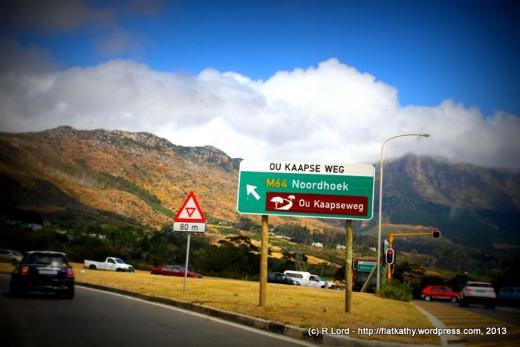
Ou Kaapse weg
The Ou Kaapse Weg is probably named so because of the old wagon route higher up the mountain. This road was used from the 1800s to transport ore from the silver mine, which can be seen lower down on the mountain. The old road is accessible to hikers.
The current road runs roughly parallel to the wagon track but is relatively modern, having been completed in 1968
The pass covers a distance of 10,6 km. There are 26 bends, curves, and corners, which include 3 full horseshoe bends and another 3 corners in excess of 90 degrees.
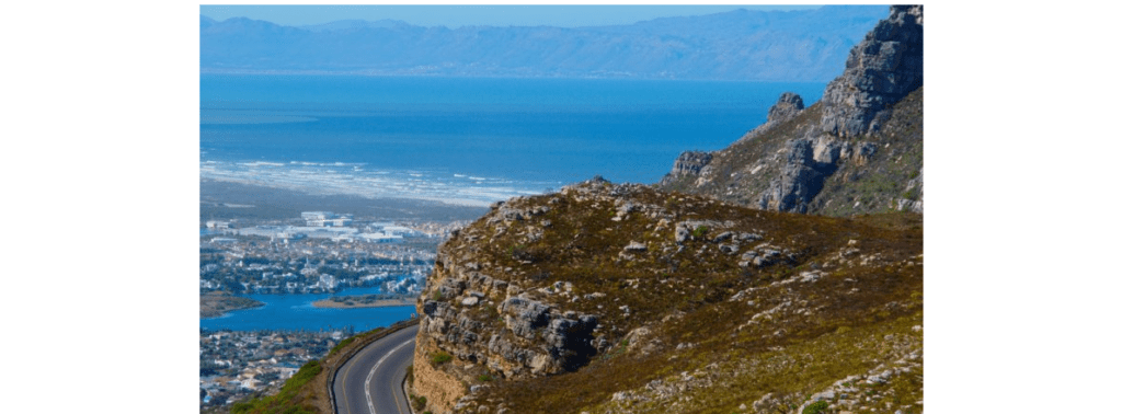
From the pass, you can get a magnificent view over the whole of False Bay. The road travels through the Steenberg mountains and the Silvermine Nature Reserve. The entrance to the reserve is near the summit. If you are driving South, the road begins at Westlake and heads towards Muizenberg, the Southern Peninsula, and on to Cape Point
FAQs about Ou Kaapse Weg
1. What is Ou Kaapse Weg?
Ou Kaapse Weg (M64) is a scenic mountain pass linking Tokai and Noordhoek in Cape Town. It crosses the Silvermine section of the Table Mountain National Park and offers panoramic views of False Bay and the Cape Peninsula.
2. Where does Ou Kaapse Weg start and end?
It starts in Tokai (near Steenberg Road) and ends near Noordhoek, where it connects to Chapman’s Peak Drive and Kommetjie Road.
3. How long is the pass?
The pass is about 10 km long, climbing to roughly 315 metres above sea level at the summit.
4. Is there a toll on Ou Kaapse Weg?
No. Ou Kaapse Weg is toll-free and open to all vehicles.
5. Is Ou Kaapse Weg safe to drive?
Yes. The road is tarred and well-maintained. Drive carefully in mist, rain, or high winds, especially on the bends near the summit. Avoid stopping on the shoulders at night.
6. Why is it called “Ou Kaapse Weg”?
The name means “Old Cape Road” in Afrikaans. It was the original inland route over the mountain before coastal roads like Chapman’s Peak were built.
7. Are there viewpoints along Ou Kaapse Weg?
Yes. There’s a viewing area near the top with space to pull over safely and take photos of the Silvermine Valley, False Bay, and the Cape Flats.
8. Can I hike in the area?
Yes. The Silvermine Nature Reserve has hiking trails accessible from Ou Kaapse Weg, including the Elephant’s Eye Cave and Silvermine Reservoir trails.
9. Does Ou Kaapse Weg close in bad weather?
Occasionally. The City of Cape Town closes it temporarily during heavy fog, fires, or strong winds. Always check local traffic updates before travelling.
10. Are there any facilities along the road?
There are no shops or petrol stations on the pass itself. The nearest services are in Tokai, Noordhoek, and Sun Valley.
11. Can cyclists use Ou Kaapse Weg?
Yes, but it’s a steep climb with fast-moving traffic. Cyclists should use high-visibility gear and travel early in the morning when traffic is lighter.Kaapse weg
Updated October 2025