
-
- Province: Western Cape
- Coordinates; 34°7′S 18°26′E
- Area: 4.15 km2
- Municipality: City of Cape Town
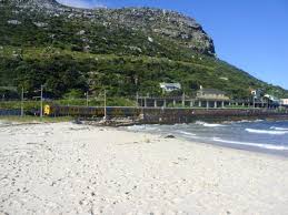
Clovelly sits on the False Bay coastline on the Cape Peninsula in the Western Cape, between Fish Hoek and Kalk Bay. The suburb stretches from the mountainside down to the sheltered waters of Clovelly Beach and is accessed via the M4 coastal road and the railway line that runs along the bay.
History of Clovelly
This is a small suburb between Fishhoek and Kalk Bay. The stretch of beach is quieter than Fishhoek Beach. The offshore ridge causes the waves to slow down and is perfect for novice surfers. Dolphins and whales can often be seen between June and November
…………..
Clovelly developed in the late 19th and early 20th centuries as part of the agricultural landscape around the Silvermine River valley. The area was originally known as Mayfield Estate, and the name Clovelly is believed to have been inspired by Clovelly in Devon, England.
Clovelly Station opened in 1936 to serve the growing settlement. Built close to the rocks beside the railway line, it became a popular, although unofficial, fishing spot. The station remained in use until 1990.
A concrete footbridge providing access between the road and the beach was built in 1930. It stood at the foot of Trappieskop, where the terrain made access difficult, and provided an important route to the beach. The bridge was demolished in 1990, around the time the railway station closed.
Clovelly lies at the mouth of the Silvermine River valley. The broad, flat valley extending from Clovelly towards Noordhoek and Kommetjie was once beneath the sea. During periods when sea levels were considerably higher, the landscape of the Cape Peninsula was very different, and the valley formed part of a marine passage separating the southern and northern sections of the peninsula.
The Silvermine River has also been the subject of local conservation efforts. Proposals to substantially canalise the lower river and wetlands with concrete stormwater channels were opposed by residents and conservationists, who pushed instead for ecological rehabilitation of the river system. The lower Silvermine remains an important natural wetland and river environment.
At the mouth of the Silvermine River, weathered remains of old stone and timber structures can still be seen along the beach. These are believed to date back more than a century and were associated with attempts to protect the road and surrounding land from coastal erosion.
Another thing that makes the area special is that it is home to several seaweeds found only around the Cape Peninsula, including Chaetomorpha, Cladophora and Laurenciophila minima
The postal code in Clovelly is 7975
Things to see and do in Clovelly
- Beach
- Golf Club
Resources
For permits, fishing rules, shell collecting regulations and other practical outdoor information, see the Colourdots coastal and nature use guide
local WEATHER TODAY
Browse businesses and places to visit in clovelly

Useful Numbers in Clovelly
Residents and visitors can find important local contact numbers below, including police, medical services, utilities, and community facilities
-
Emergency Services
- Police: Muizenberg 021 787 9000
- Fire: 021 480 7700 Fishhoek
- Ambulance: 10177
-
Medical
- Closest hospital: False Bay Hospital 021 782 1121
- Pharmacy; Warrens (Fishhoek) 021 782 2424
-
Municipal & Utilities
- Water:0860 103 089
- Electricity: 0860 103 089
-
Transport & Roads
- Traffic department: Fishhoek 0860 103 089
- Road Emergencies / SANRAL: 0800 204 204
-
Community & Safety
- NSRI 087 094 9774
- 24 hour Poisons Information Helpline of the Western Cape: 0861 555 777.
- Childline South Africa: 116
- SPCA: Cape Of Good Hope – 021 700 4140
-
Local Contacts and Community Resources
- Post office; 021 782 2916
- Library:021 400 7101 Fish Hoek
- Colourdots is an independent regional information resource for the Western Cape.
Learn more about the project HERE