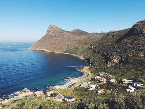
Smitswinkel Bay
This name, Smitswinkel Bay, dates back to about 1744. But it isn’t clear where the beach got its name from. Some say there was a blacksmith who lived in the area. Possibly it was named after a farm owner called Smit, and then there’s the theory that two stones on the shoreline look like anvils, hence the name. Possibly it was the site of sales of goods from shipwrecks. It is a secluded bay situated on the coastal drive between Simon’s Town and the entrance to the Cape Point Nature Reserve.
Smitswinkel Bay lies at the bottom of a cliff and is hidden beneath the curve of the road that leads to the reserve. It was first called Patience after the tiny stream that flows down a small valley into the bay, as mariners who wanted to fill their water casks had to be very patient because of the slow trickle of water. Back then, Smitswinkel could only be reached by boat. Smit was a farmer who owned a property close to the beach.
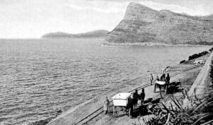
Smitswinkel Bay 1914
In 1916 it was proclaimed as a campsite. Day hike permits are available, and there is a tented campsite run by Sanparks. The beach is relatively inaccessible but can be reached on foot down a very steep slope. It will take about 15 to 20 minutes to walk down the steep 120-meter zig-zag footpath to the beach. This discourages the crowds, but for a diving adventure, it is well worth the effort. Bring enough water and food as there is no shop there despite the name. There’s also no electricity at Smitswinkel. Do not feed or encourage baboons, as they can be dangerous.
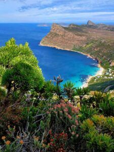
This bay is an adventure for deep-sea dives where divers can explore shipwrecks. Five wrecks are here in the vicinity at a maximum depth of 34 metres. The wrecks were deliberately scuttled by the South African Navy in the 1970s to make an artificial reef. Two frigates, the Good Hope and Transvaal and two trawlers, Oratava and Princess Elizabeth, were wrecked off the bay. Also, the diamond dredger, Rockeater. When one dives the wrecks, large blast holes that caused the sinking can be seen in the sides of the ships. The SAS Transvaal was abandoned in 1978, MV Orotava in 1983, and the SAS Good Hope was sold for scrap metal in 1978.
The only catch is you have to go take scuba diving gear to view these abandoned sites, but what an adventure! There is an extensive coral reef that has grown on the vessels, which supports masses of aquatic life.
The fish spotter
This person played an important role in the trek fishing business. There was a time when there were 8 trek fishing families operating from Smitswinkels Bay to Glencairn. All of them would go out twice or three times a day. Some would even trek during the night when fish were abundant.
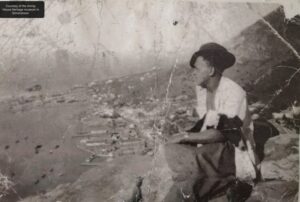
The Sighter would climb high up on the mountain, scouring the coast looking for shoals of fish. Early in the morning, he would climb the mountain to his hut with his lunch, 2 flags, a whistle and binoculars. These were the most experienced fishermen who could even tell the type of fish and the amount in the water by just studying the water. When a shoal was spotted, he would blow his whistle and guide the skipper with his flags to exactly where the nets should be thrown.
With this knowledge, they hardly lost a catch. As time passed and the group areas act moved people out of these trekkers were slowly closed down, and so was a life, a livelihood and an occupation destroyed.
Smitswinkel Bay
Residents (and their dogs) in the village use gas or opt for solar panels. It’s a beautiful beach, but it’s often windy, and the water is icy, and at high tide, the beach is almost completely underwater.
This beach is the last beach after Simon’s Town and the Cape Point Nature Reserve.
Check the tides here
Best beaches in the Western Cape article