Province: Western Cape
Winelands
Coordinates:33°55′S 18°57′E
Area:0.94 km2
Municipality: Stellenbosch
Jump to:History of Kylemore |Useful Numbers in Kylemore
Kylemore is a small village in the Western Cape, situated inland from the Overberg region, between Bredasdorp and Napier. It lies along the R316 and is surrounded by farmland and gentle hills. The area is primarily agricultural, with a quiet rural community.
History of Kylemore
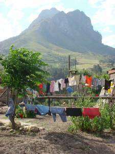
Kylemore is a rural village in the Cape Winelands, situated along the Helshoogte Pass between Stellenbosch and Franschhoek. It was established in 1955 and is named after a town in Ireland.
The village is home to a community of over 4,000 people and is surrounded by mountains and rivers, with access to walking trails in the surrounding countryside. Despite its scenic setting, Kylemore remains economically vulnerable.
Employment opportunities within the village are limited, with no significant industry. Many residents rely on seasonal agricultural work on nearby farms, particularly during harvest time. Outside of this season, unemployment levels are high, and many depend on opportunities in nearby towns such as Stellenbosch, Paarl, and greater Cape Town. For the rest of the time, they rely on personal endeavours, but opportunities are limited
Limited access to resources continues to affect the community. School leavers often struggle to find employment, and financial constraints make it difficult for many to pursue tertiary education or travel in search of work.
Despite these challenges, Kylemore has a strong sense of community. The village is largely Christian, with several active churches that play an important social and cultural role in daily life.
The postcodes are 7600 (Streets) and 7680 (Boxes)
Resources
Practical information for the Western Cape, Regulations, permits and helpful tips. See the Colourdots coastal and nature use guide
local WEATHER TODAY
Browse businesses and places to visit in Kylemore

Useful Numbers in Kylemore
Numbers are mostly Stellenbosch numbers
Residents and visitors can find important local contact numbers below, including police, medical services, utilities, and community facilities. Numbers are mostly Stellenbosch numbers
-
Emergency Services
- Police: 021 888 5940
- Fire: 021 808 8888
- Ambulance: 10177
-
Medical
- Closest hospital; Stellenbosch Provincial Hospital-021 808 6100
- Clinic-021 885 2504
-
Municipal & Utilities
- Municipality-021 888 5100
- Water:021 888 5100
- Electricity:021 888 5100
-
Transport & Roads
- Traffic department:021 808 8800
- Community & Safety
-
Local Contacts and Community Resources
- SPCA: 021 700 4140 Cape Of Good Hope
- Post office;021 886 7521
- Library:Stellenbosch-021 808 8385
-
Schools in Kylemore
- Secondary School-021 885 1341
- P.C. Petersen Primary School-021 885 1616
- Kylemore Kleuterskool-021 885 2286
- Find a comprehensive list of Cape Town Emergency Numbers HERE
- Colourdots is an independent regional information resource for the Western Cape.
Learn more about the project HERE