- Province: Western Cape
- Coordinates 33°54′55″S 18°25′08″E
- Area 0.30 km2ter
- Municipality City Of Cape Town
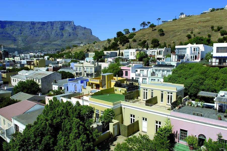
De Waterkant lies immediately east of the central Cape Town city centre and west of the Foreshore. It is bordered by Green Point to the north and the Bo-Kaap to the east. The suburb is compact and walkable, offering scenic streets, boutique shops, and easy access to both the V&A Waterfront and Table Mountain.
History of De Waterkant
De Waterkant is a sub-district of Green Point in Cape Town and is often referred to today as the city’s “pink district.” Its history, however, extends back to the late 18th century and forms part of Cape Town’s earliest urban development.
During the colonial period, the area developed as a mixed, working-class neighbourhood. It was home to freed slaves, artisans, labourers, and small traders, many of whom were part of the wider Cape Malay and Muslim community. At the time, the boundaries of what is now known as Bo-Kaap were far broader than they are today and included De Waterkant, parts of Green Point, the Chiappini Street and upper Buitengracht area, and Schotschekloof. The current borders of Bo-Kaap represent a much-reduced remnant of this once larger community.
Before apartheid formally enforced racial segregation, these areas functioned as interconnected neighbourhoods with shared religious, cultural, and economic ties. Even where residents were not immediately removed under apartheid legislation, many communities experienced gradual economic pressure. Rising municipal rates, increasing maintenance costs, the expiry of long-term leases with the City, and rapidly escalating property values made it difficult for families to remain. In many cases, people left not by choice but because staying became financially impossible. This process amounted to economic displacement rather than voluntary relocation.
Architecturally, De Waterkant developed with a mix of Georgian and Cape Dutch–influenced buildings, many of which were modest homes and workshops. In the late 20th century, large parts of the area underwent restoration. While this preserved much of the historic built fabric, it coincided with a major demographic change.
After 1994, De Waterkant was deliberately rebranded and marketed as a European-style, lifestyle-focused neighbourhood, known for design, dining, and LGBTQ-friendly spaces. This new identity gained prominence, while the area’s earlier Cape Malay and working-class history faded from public view. As properties changed hands, wealthier buyers moved in, followed by developers and short-term rentals. As the original community lost critical mass, cultural continuity weakened, and much of the area’s social history became less visible.
Today, De Waterkant is one of Cape Town’s most sought-after neighbourhoods. Its streetscape still reflects layers of its past, but its present identity is shaped by redevelopment, rebranding, and long-term patterns of displacement that mirror broader changes across the city.
Post code for De Waterkant is 8001
Resources
Practical information for the Western Cape: regulations, permits, and helpful tips. See the Colourdots coastal and nature use guide
WEATHER IN DE WATERKANT
Browse businesses and places to visit in De Waterkant

Useful Numbers
Residents and visitors can find important local contact numbers below, including police, medical services, utilities, and community facilities in and around
-
Emergency Services
- Police: 021 403 1000 (Table Bay Harbour Police Station)
- Fire: Central fire station 021 444 8963
- Ambulance: 10177- Cape Metro Council- 021 487 2045
-
Medical
- Closest hospital/clinic; Netcare Christiaan Barnard Memorial Hospital-021 441 0000
- Pharmacy; Cape Quarter 021 418 0360
-
Municipal & Utilities
- Municipality 0860 103 089
- Water:0860 103 089
- Electricity:0860 103 089
-
Transport & Roads
- Traffic department: 0860 103 089 (Gallows Hill)
-
Community & Safety
- SPCA:021 700 4140
- NSRI 087 094 9774
-
Local Contacts and Community Resources
- Post office;021 464 1707
- Library– Cape Town central-021 444 0209
-
Schools in De Waterkant
- Vega School Cape Town-021 461 8089
- Find a comprehensive list of Cape Town Emergency Numbers HERE
- Colourdots is an independent regional information resource for the Western Cape.
Learn more about the project HERE